



National Park · Nong Bua Lamphu · Khon Kaen
Phu Kao–Phu Phan Kham National Park
อุทยานแห่งชาติภูเก้า-ภูพานคำ
Mountains, Ancient Rock Landscapes & the Wide Waters of Ubolratana Reservoir
Nong Bua Lamphu & Khon Kaen · Northeastern Thailand — Isan
A landscape where sandstone mountains, prehistoric traces, sacred places, seasonal forest and broad reservoir views meet.
A Landscape of Contrasts
At Phu Kao–Phu Phan Kham, sandstone mountains rise above dry dipterocarp forest, unusual formations reveal the work of wind and water over geological time, and the wide waters of Ubolratana Reservoir stretch beneath the Phu Phan Kham range.
Yet the park is more than a natural landscape. Caves and rock shelters preserve traces of prehistoric human activity, while sacred places and local legends connect the mountains with generations of people who have lived around them.
For travellers exploring Isan, this is a destination where nature, geology, archaeology, local belief and lakeside scenery meet in one national park.
This layered landscape is part of ThailandLover’s Nature & Parks collection.
At a Glance
- Official Name
- Phu Kao–Phu Phan Kham National Park
- Thai Name
- อุทยานแห่งชาติภูเก้า-ภูพานคำ
- Provinces
- Nong Bua Lamphu and Khon Kaen
- National Park
- 50th national park of Thailand
- Established
- 20 September 1985
- Area
- Approximately 201,250 rai (322 km²)
- Landscape
- Sandstone mountains, seasonal forest, streams, caves and reservoir scenery
- Major Water Feature
- Ubolratana Reservoir
- Best Known For
- Rock formations, prehistoric traces, viewpoints and reservoir sunsets
- Best For
- Nature, photography, archaeology, families, camping and road trips
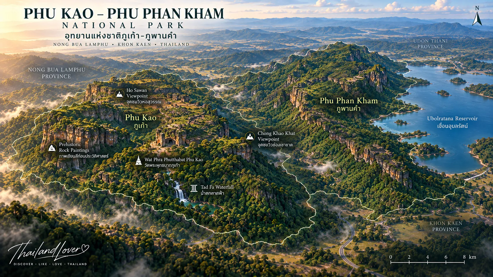
The park divides geographically into two distinctive landscapes. Phu Kao is known for mountains, sandstone formations, caves, forest and prehistoric traces. Phu Phan Kham follows a long ridge above Ubolratana Reservoir, producing the park’s broadest water-and-mountain views.
Why Visit Phu Kao–Phu Phan Kham?
One moment you may be walking through dry forest among enormous sandstone boulders. Another may take you to a shelter associated with ancient people. Elsewhere, the landscape opens dramatically toward the reservoir created by Ubolratana Dam.
The park works especially well for travellers who prefer landscapes with layers of meaning rather than one headline attraction. Geological stories live in the rocks, ecological stories in the forest, archaeological stories in the shelters and cultural stories in sacred places and local traditions.
Ancient stone. Ancient people. Dry forest. Sacred places. Mountain ridges. A vast reservoir.
The Story Behind the Name
- Phu Kao
- The name is associated with a group of hills distinguished by sandstone terrain, rocky terraces, caves and forested slopes. Long erosion has shaped exposed sandstone into unusual forms.
- Phu Phan Kham
- This ridge belongs to the wider Phu Phan mountain system. It extends along the eastern side of Ubolratana Reservoir, creating an elevated landscape above the water.
A Landscape Shaped by Stone
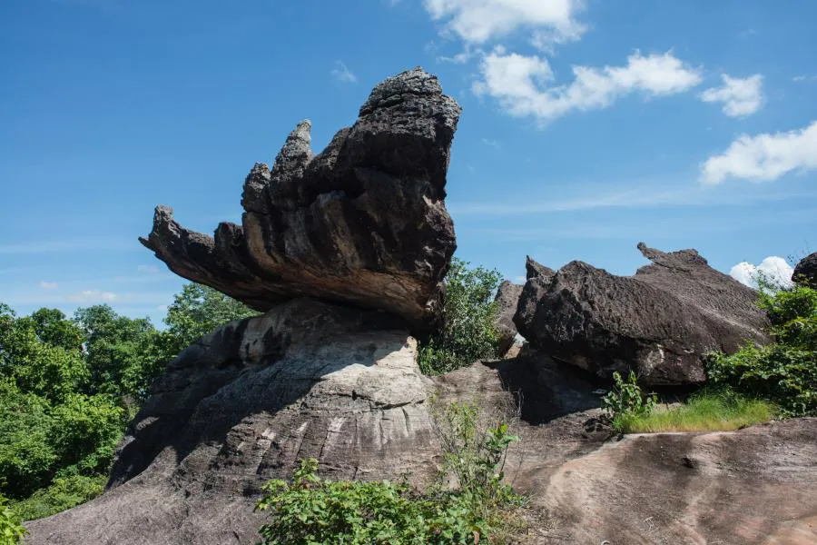
Phu Kao lies within the geological landscape of the Khorat Plateau, where sandstone occurs widely across northeastern Thailand. Rain, flowing water, wind and temperature changes have gradually reshaped exposed rock into large outcrops, terraces, shelters, caves and weathered boulders.
Some formations resemble mushrooms or natural sculptures. They are not built structures, but examples of erosion working on sandstone over geological time. Forest growing between the exposed surfaces gives Phu Kao a character unlike the densely wooded mountain parks of northern Thailand.
The Phu Kao Landscape
Phu Kao is the more geological and archaeological side of the park. Its hills, forest, exposed sandstone and rocky ground show how closely nature and human history are connected.
Natural caves and shelters offered prehistoric communities protection, while the surrounding forest supplied water, plants and other resources. Rock paintings and archaeological traces remind visitors that Thailand’s heritage extends well beyond temples and historic cities.
Prehistoric Traces
Rock shelters and caves preserve paintings and traces associated with people who lived in this region thousands of years ago. These images are archaeological evidence, offering clues about prehistoric life, belief and the relationship between people and their environment.
Sacred Places & Viewpoints
- Wat Phra Phutthabat Phu Kao
- A cultural site associated with sacred footprints in the rock. Local traditions give the natural and archaeological landscape additional spiritual meaning. Dress respectfully and follow temple rules.
- Ho Sawan
- An elevated viewpoint structure among the rocks, offering a perspective across the surrounding forest and sandstone terrain. It suits short exploratory walks and landscape photography.
Phu Phan Kham & Ubolratana Reservoir
The park changes character on the Phu Phan Kham side, where mountain ridges meet the enormous Ubolratana Reservoir. Created by Ubolratana Dam on the Nam Phong River, the water can look almost like an inland sea between the surrounding mountains.
Water level, weather, clouds and seasonal vegetation continually alter the view. Higher water creates a broad continuous expanse; drier periods expose more shoreline. Clear cool-season skies, green-season colour and monsoon clouds each produce a different version of Phu Phan Kham.
- Chong Khao Khat Viewpoint
- An elevated panorama combining mountain, forest and water. Early morning brings softer light; late afternoon warms the reservoir and ridges.
- Phu Aen Skywalk
- A glass viewing platform extending toward the reservoir landscape. Follow posted safety rules and check current opening arrangements before travelling.
Forests & Wildlife
- Dry Dipterocarp Forest
- The park’s characteristic open woodland includes species such as Dipterocarpus obtusifolius, Shorea obtusa, Shorea siamensis and Dipterocarpus tuberculatus. Many trees shed leaves in the dry season.
- Mixed Deciduous Forest
- Lower and moister areas around valleys and streams support species such as Burmese padauk, Afzelia, Irvingia, Terminalia and Dalbergia.
- Dry Evergreen Forest
- Smaller evergreen patches occur near streams and other moist locations, remaining green when the surrounding seasonal forest becomes drier.
- Wildlife
- Open woodland and mixed forest support birds, reptiles, small mammals and other wildlife adapted to seasonal conditions. Move quietly, never feed animals and observe from a respectful distance.
Climate & Best Time to Visit
- Cool season · November–February
- Usually the most comfortable time for walking, viewpoints and camping. Temperatures are lower and skies are often clearer; January is typically the coolest month.
- Hot season · March–May
- April is generally hottest. Exposed rock can become extremely warm at midday, so explore early or late and carry plenty of water.
- Rainy season · June–October
- Forest turns greener and seasonal streams become more active. September generally brings the heaviest rainfall; sandstone may be slippery.
There is no single perfect month: choose November–February for comfort, the rainy season for greener landscapes and late afternoon for warm reservoir photography.
Things to Do
- Explore the sandstone landscape. Look for weathering patterns, cracks and textures as well as the largest formations.
- Visit prehistoric sites. Follow designated access to rock paintings and archaeological traces without touching the surfaces.
- Visit Wat Phra Phutthabat Phu Kao. Combine scenery with local religious culture and approach active sacred areas respectfully.
- See Ubolratana Reservoir from above. Head to the Phu Phan Kham side for the park’s defining water-and-mountain views.
- Walk the Phu Aen Skywalk. Experience a panoramic glass-platform view, subject to current operations.
- Watch the sunset. Clear late afternoons bring warm colour to the reservoir and silhouetted ridges.
- Camp in the park. Use designated areas and confirm facilities and availability before travelling.
Camping, Accommodation & Facilities
The official DNP booking system lists the Phu Kao–Phu Phan Kham Camping Area, with tents and selected equipment including sleeping bags, sleeping mats and pillows. Park accommodation may include Phu Kao 101 (Kulap Hin), together with youth-camp facilities.
Visitor information also lists park headquarters, accommodation, camping areas, tents, youth camps, meeting facilities and basic camping equipment. This remains a protected natural area rather than a resort, so bring essential personal items and confirm availability through the current DNP booking system.
Entrance Fees
Phu Kao–Phu Phan Kham is listed in Department of National Parks fee Group 1. Published admission rates are:
- Thai Adult
- 20 THB
- Thai Child
- 10 THB
- Foreign Adult
- 100 THB
- Foreign Child
- 50 THB
Vehicle or service charges may apply. Government fees and regulations can change, so verify current information before your visit.
How to Get There
From Khon Kaen, the Ubolratana area provides a practical approach to the Phu Phan Kham side. From Nong Bua Lamphu, routes through Non Sang provide access toward Phu Kao.
A private or rental car is generally the most convenient option because attractions are spread across a large protected landscape. Public transport becomes limited away from the main towns.
Suggested One-Day Visit
- Morning · Phu Kao
- Explore sandstone, forest and archaeological areas, then visit cultural sites around Wat Phra Phutthabat Phu Kao where access permits.
- Midday · Rest
- Take lunch away from exposed rock and avoid long periods under the strongest sun.
- Afternoon · Phu Phan Kham
- Travel to the reservoir side and let the view change as the light softens.
- Late afternoon · Skywalk & sunset
- Visit Phu Aen Skywalk or nearby viewpoints, subject to operating hours, then leave before darkness unless staying overnight.
Suggested Two-Day Experience
- Day 1 · Phu Kao
- Explore sandstone formations, prehistoric sites, forest and Wat Phra Phutthabat Phu Kao, then camp or stay nearby.
- Day 2 · Phu Phan Kham
- Travel toward the reservoir, explore the viewpoint area, visit Phu Aen Skywalk if operating and photograph sunset before continuing toward Khon Kaen or Nong Bua Lamphu.
Photography Guide
- Rock formations
- Use low early light to emphasize cracks, texture and shadow across sandstone.
- Forest
- Rainy-season vegetation is greener and denser; dry season reveals the woodland’s open structure.
- Reservoir
- Late afternoon creates warm light across the water. A wide-angle lens helps connect reservoir and ridges in one frame.
- Early morning
- Softer light, fewer visitors and occasional atmospheric haze can reward an early start.
Travel Tips & Leave No Trace
- Carry enough drinking water, especially from March to May
- Wear walking shoes with good traction on uneven or wet sandstone
- Bring a hat, sunscreen, sunglasses and insect repellent
- Never touch, wet, trace, scratch or mark prehistoric paintings
- Stay on designated routes and behind safety barriers
- Check weather before walking on exposed rock
- Do not remove rocks, plants or archaeological material
- Carry rubbish out and never feed wildlife
- Keep noise low so animals can behave naturally
Who Is This Park For?
- Nature lovers
- Seasonal forest, geology and broad mountain landscapes.
- Photographers
- Sandstone, forest, reservoir, mountain silhouettes and changing light.
- History & archaeology enthusiasts
- Prehistoric paintings and evidence of ancient human activity.
- Families
- Selected sightseeing areas suit relaxed visits, with close supervision around cliffs, rocks and water.
- Campers
- Designated camping offers a quieter experience beyond a day trip.
- Road trippers
- A natural stop on routes linking Khon Kaen, Ubolratana and Nong Bua Lamphu.
Nearby Experiences
Depending on your route, combine the park with Ubolratana Dam and Reservoir, Nong Bua Lamphu’s cultural attractions, Wat Tham Klong Phen, local communities and markets, the Khon Kaen countryside or other natural attractions around Nong Bua Lamphu.
Essential Information
- National Park
- Phu Kao–Phu Phan Kham National Park
- Thai Name
- อุทยานแห่งชาติภูเก้า-ภูพานคำ
- Region
- Northeastern Thailand · Isan
- Provinces
- Nong Bua Lamphu and Khon Kaen
- Status
- Thailand’s 50th national park · 20 September 1985
- Area
- Approximately 201,250 rai (322 km²)
- Main Landscapes
- Sandstone mountains, dry forest, caves and reservoir
- Recommended Season
- November–February for cooler weather
- Camping
- Available in designated areas
- Best For
- Nature, geology, archaeology, photography, camping and road trips
Frequently Asked Questions
- Where is Phu Kao–Phu Phan Kham National Park?
- It spans Nong Bua Lamphu and Khon Kaen provinces in northeastern Thailand, with the distinct Phu Kao and Phu Phan Kham mountain landscapes.
- Why is it called Phu Kao–Phu Phan Kham?
- The name combines the park’s two distinctive mountain areas: Phu Kao and Phu Phan Kham.
- What is the park famous for?
- Sandstone landscapes, dry forest, caves, prehistoric traces, cultural sites, viewpoints and Ubolratana Reservoir.
- Can I see Ubolratana Reservoir from the park?
- Yes. Elevated viewpoints in the Phu Phan Kham section look across the water and surrounding mountains.
- Is there a skywalk?
- Phu Aen Skywalk is associated with the reservoir-viewing area. Check current operating arrangements before visiting.
- Can I camp overnight?
- Yes. Designated camping and selected equipment are listed by the Department of National Parks, subject to availability.
- What is the best season?
- November–February is generally most comfortable. The rainy season is greener, while summer is considerably warmer.
- Is the park suitable for families?
- Selected sightseeing areas are suitable, but children need close supervision around rocky terrain, viewpoints, cliffs and water.
- Do I need a car?
- A private or rental car is generally the easiest way to reach attractions spread across the park.
- Can I visit the prehistoric rock paintings?
- Yes, where access is permitted. Follow designated routes and never touch or mark archaeological surfaces.
- How long should I spend here?
- A focused visit can fit into one day; two days allows a more relaxed exploration of both landscapes.
Related Destinations
- Phu Phrabat Historical Park
- UNESCO-listed sandstone, prehistoric paintings and Dvaravati sacred boundaries in Udon Thani.
- Nam Phong National Park
- Forest and viewpoints around another side of the Ubolratana Reservoir landscape.
- Nature & Parks
- Explore more protected landscapes in ThailandLover’s national-park collection.
Location
Find Phu Kao–Phu Phan Kham National Park
Nong Bua Lamphu · Khon Kaen · Northeastern Thailand