

Historical Park · UNESCO World Heritage · Udon Thani
Phu Phrabat Historical Park
อุทยานประวัติศาสตร์ภูพระบาท
Where Ancient Rocks Became Sacred Landscapes
Ban Phue, Udon Thani · Northeastern Thailand — Isan
A landscape where geology became architecture, and architecture became cultural memory — prehistoric rock paintings, Dvaravati Sīma stones and the iconic Ho Nang Usa.
Where Ancient Rocks Became Sacred Landscapes
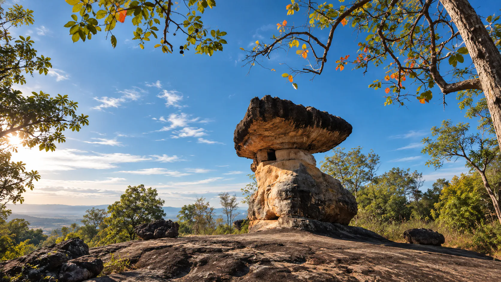
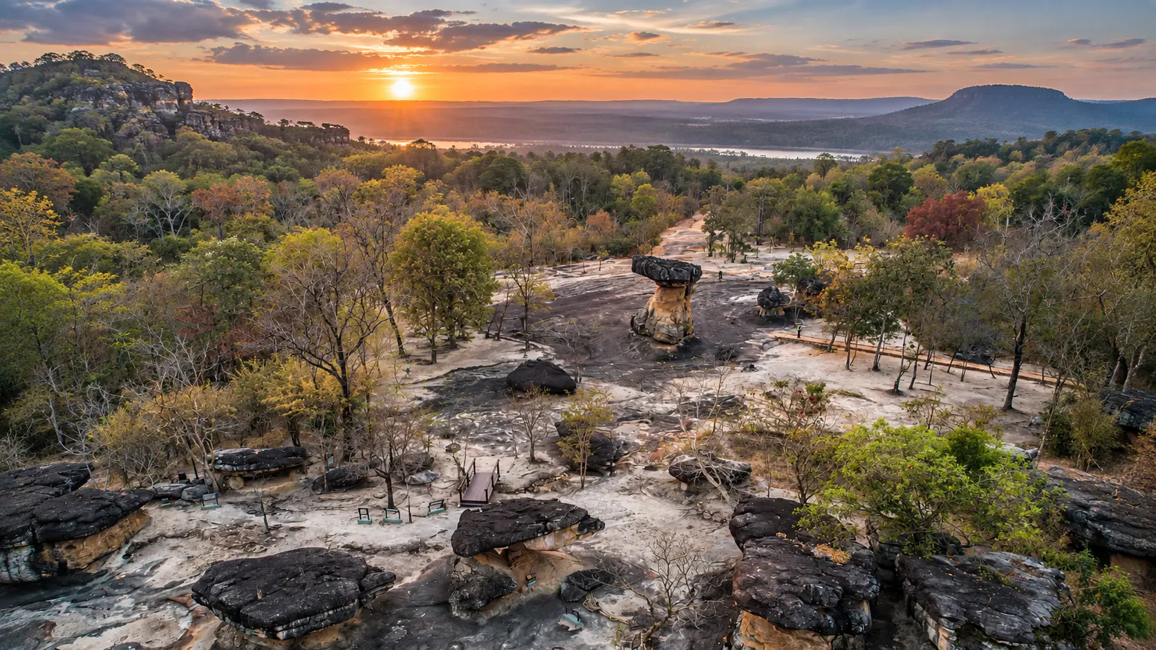
In the western highlands of Udon Thani, enormous sandstone formations rise from a forested plateau. Some look like mushrooms. Some resemble tables. Others form natural shelters, caves and overhanging chambers.
But Phu Phrabat is not simply a geological landscape.
For thousands of years, people have interacted with these rocks — first using natural shelters as places of habitation, and later transforming selected formations into sacred spaces. Prehistoric paintings survive on rock surfaces. Ancient stone markers were placed around modified shelters. Buddhist religious spaces were established. Later cultural influences left additional traces. And local communities eventually connected many of the monuments with the legendary story of Usa and Baros.
This extraordinary combination of natural geology and human transformation is what makes Phu Phrabat Historical Park different from most historical parks in Thailand.
In 2024, UNESCO recognized this cultural landscape as a World Heritage Site under the name:
Phu Phrabat, a testimony to the Sīma stone tradition of the Dvaravati period
The inscription recognizes not merely individual monuments, but a landscape in which natural rock formations, prehistoric human activity, Buddhist sacred boundaries and later cultural traditions have remained physically connected over time.
For ThailandLover, Phu Phrabat is best understood as a landscape where geology became architecture, and architecture became cultural memory.
Quick Facts
- Official Name
- Phu Phrabat Historical Park
- Thai Name
- อุทยานประวัติศาสตร์ภูพระบาท
- Province
- Udon Thani
- District
- Ban Phue
- Subdistrict
- Mueang Phan
- Region
- Northeastern Thailand — Isan
- Mountain Range
- Phu Phan Range
- Landscape
- Sandstone mountain, rock shelters, forest and cultural sites
- Elevation
- Approximately 320–350 metres above mean sea level
- Historical Park Opened
- 26 June 1992
- UNESCO Inscription
- 27 July 2024
- UNESCO Category
- Cultural Landscape
- UNESCO Criteria
- (iii), (v)
- UNESCO Property
- Phu Phrabat, a testimony to the Sīma stone tradition of the Dvaravati period
- Property Structure
- Serial property of 2 components
- Main Component
- Phu Phrabat Historical Park
- Associated Component
- Sīma Cultural Site at Wat Phra Phuthabat Buaban
- Famous Landmark
- Ho Nang Usa
- Major Themes
- Prehistoric rock paintings, modified rock shelters, Sīma stones, Dvaravati Buddhist landscape
- Management
- Fine Arts Department, Ministry of Culture
The Fine Arts Department identifies the park in Mueang Phan Subdistrict, Ban Phue District, Udon Thani Province, on the Phu Phan sandstone mountain range, approximately 320–350 metres above mean sea level.
First: Phu Phrabat Is Not a National Park
This distinction matters.
Phu Phrabat Historical Park is a historical and archaeological heritage site administered by the Fine Arts Department.
It is not a national park administered by the Department of National Parks. The Thai name อุทยานประวัติศาสตร์ภูพระบาท means Phu Phrabat Historical Park. The word อุทยาน can cause confusion because it also appears in names of natural parks — but here the institution is a historical park under the Fine Arts Department.
Its primary purposes are archaeological research, conservation, protection of ancient monuments, interpretation, cultural education and heritage tourism. The park sits within a broader forested landscape, but its principal identity is archaeological and cultural heritage.
It should also not be confused with Phu Phan National Park — a separate natural protected area within the same mountain system.
Where Is Phu Phrabat?
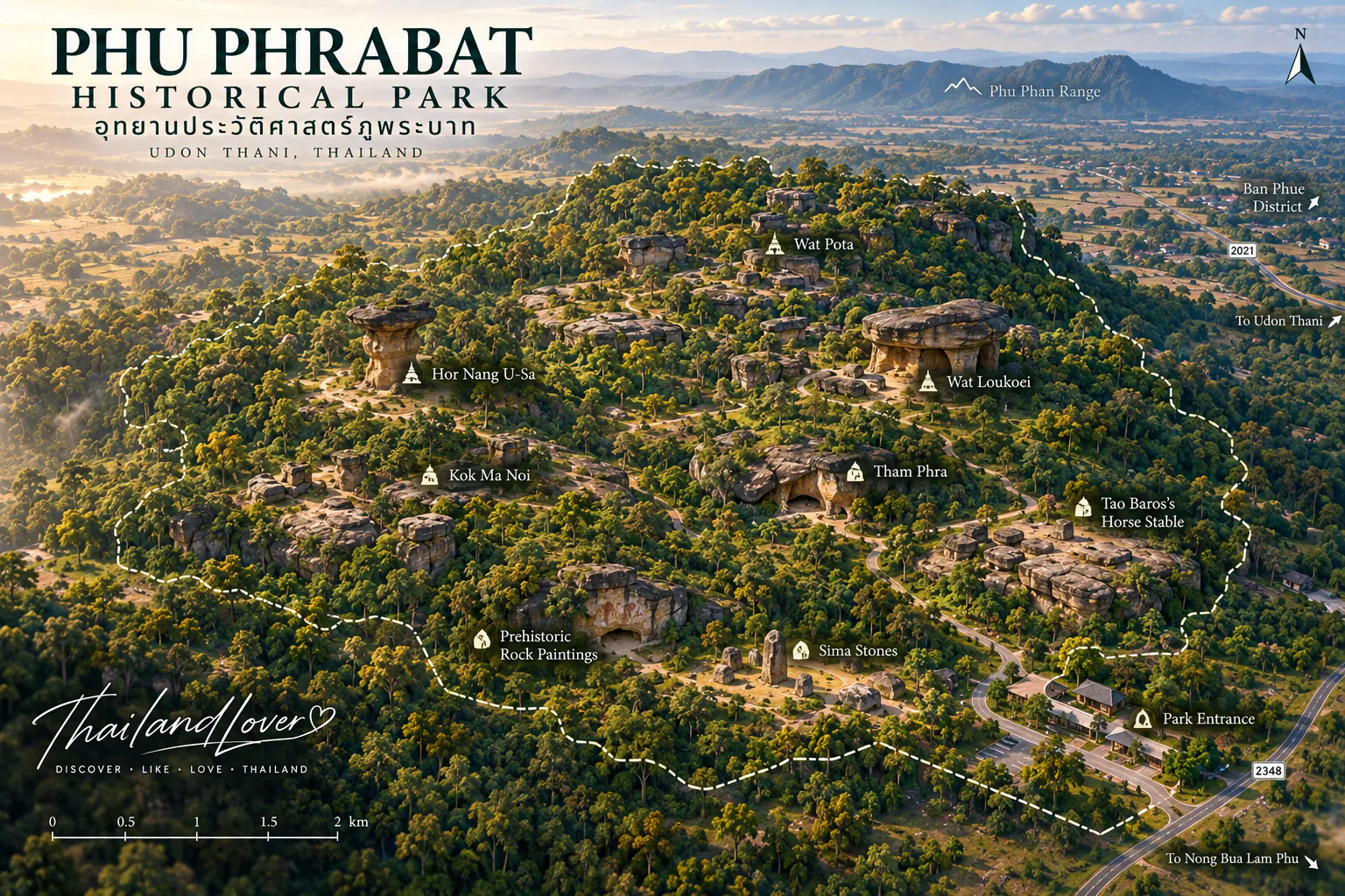
Phu Phrabat is located in Mueang Phan Subdistrict, Ban Phue District, Udon Thani Province, in northeastern Thailand. The mountain forms part of the Phu Phan Range. The site lies in the western part of Udon Thani Province.
The Fine Arts Department describes the mountain as a sandstone landscape characterized by scattered rock formations and natural rock shelters.
The Landscape Before the Monuments
Before humans modified the site, Phu Phrabat was already a remarkable geological landscape. Sandstone formations were shaped by weathering, erosion, differences in rock strength, fractures and long-term surface processes.
The result is a landscape of overhanging rock shelters, mushroom-like rocks, natural chambers, narrow openings, large slabs, balanced-looking rock masses, sandstone pillars and shallow caves.
Some formations look as though they were deliberately constructed. In reality, many began as completely natural geological formations. Human beings later modified selected ones.
The Geology of Phu Phrabat
The geological foundation belongs to the Khorat Group and is associated with Mesozoic sandstone. Harder sandstone layers resist weathering; softer layers erode more quickly. Over immense periods of time, this differential erosion creates cavities and overhangs — the unusual rock architecture visible today.
How the mushroom-shaped rocks formed
- Sandstone layers
- Beds with different resistance within the rock.
- Weathering and erosion
- Softer material erodes faster over geological time.
- Narrower central section
- A neck develops between harder upper and lower layers.
- Mushroom or table form
- The distinctive natural silhouette appears.
These formations are natural geological structures first. Their cultural importance comes from what humans subsequently did with them.
Nature Became Architecture
At many archaeological sites, humans built monuments from stone. At Phu Phrabat, the relationship is different.
Humans found natural rock shelters and formations, then enclosed some areas, carved or modified rock surfaces, installed stone markers, created religious spaces and incorporated the formations into sacred landscapes.
The architecture does not completely replace nature. It works with nature. That is why UNESCO treats the site as a cultural landscape, rather than simply a collection of isolated archaeological monuments.
Human Presence: More Than 2,000 Years
Archaeological evidence demonstrates prehistoric activity at Phu Phrabat. The Fine Arts Department describes activity approximately 2,000–3,000 years ago, while UNESCO documentation emphasizes human occupation evidenced by rock paintings extending over more than two millennia.
Evidence includes rock paintings, painted symbols, human and animal figures, hand-related imagery, geometric designs, and natural rock shelters associated with human activity. These paintings are archaeological evidence of people who used this landscape long before the historical cultures that later transformed it.
Prehistoric rock paintings
UNESCO’s nomination documentation identifies painted surfaces at 47 rock shelters within the nominated cultural landscape. The Fine Arts Department describes monochrome and polychrome paintings in red, white and yellow — including people, animals, plants, objects, symbols and geometric patterns.
Red pigments are believed to derive from natural mineral materials such as iron-rich earth and hematite, with organic substances potentially used as binding media.
What do the paintings mean?
ThailandLover does not claim that every painting has a known meaning. Archaeologists can identify many motifs, but original symbolic meanings are not always known. Some images may relate to daily life, animals, hunting, social activity, ritual or symbolic communication — but interpretation remains a scholarly question. Do not publish a definitive explanation for every prehistoric painting.
The Dvaravati Transformation
UNESCO identifies the core significance of Phu Phrabat as the Sīma stone tradition of the Dvaravati period, broadly dating from the 7th to 11th centuries CE.
Selected rock formations were incorporated into Buddhist sacred spaces. Stone boundary markers — Sīma stones — were installed around these sacred areas. The natural landscape became a religious landscape.
What Are Sīma Stones?
Sīma stones are sacred boundary markers associated with Buddhist monastic spaces. Their function was to designate the sacred boundary of a religious area.
At Phu Phrabat, these stones were placed around modified natural rock shelters, creating one of the site’s most important archaeological relationships:
natural rock shelter + human modification + Sīma boundary stones = sacred Buddhist landscape
Why the Sīma stones matter globally
Sīma stones existed elsewhere in the wider region. However, many ancient Sīma stones were later moved, reused or incorporated into newer religious sites.
UNESCO describes the Phu Phrabat mountain area as preserving the largest corpus in the world of in-situ Sīma stones from the Dvaravati period.
“In situ” means the objects remain in their archaeological context rather than having been removed and relocated. That context is crucial — an ancient stone still positioned within the sacred landscape for which it was originally used is far more informative archaeologically.
A Sacred Landscape, Not Just a Monument
Phu Phrabat should not be interpreted as “a collection of strange rocks,” nor simply as “an ancient Buddhist temple.” It is a sacred cultural landscape.
- Mountain
- Natural rock shelters formed by sandstone geology.
- Prehistory
- Human occupation and rock paintings.
- Religious modification
- Shelters adapted into sacred spaces.
- Sīma stones
- Buddhist sacred boundaries in original context.
- Later traditions
- Khmer-related, Lan Xang and living folklore layers.
- Modern conservation
- Fine Arts Department management and UNESCO recognition.
This continuity is central to the site’s UNESCO significance.
Later Cultural Influences
Phu Phrabat was not frozen in one historical period. The Fine Arts Department identifies layered traditions:
- Prehistoric traditions
- Rock paintings and human activity.
- Dvaravati tradition
- Buddhist sacred spaces and Sīma stones.
- Khmer-related influence
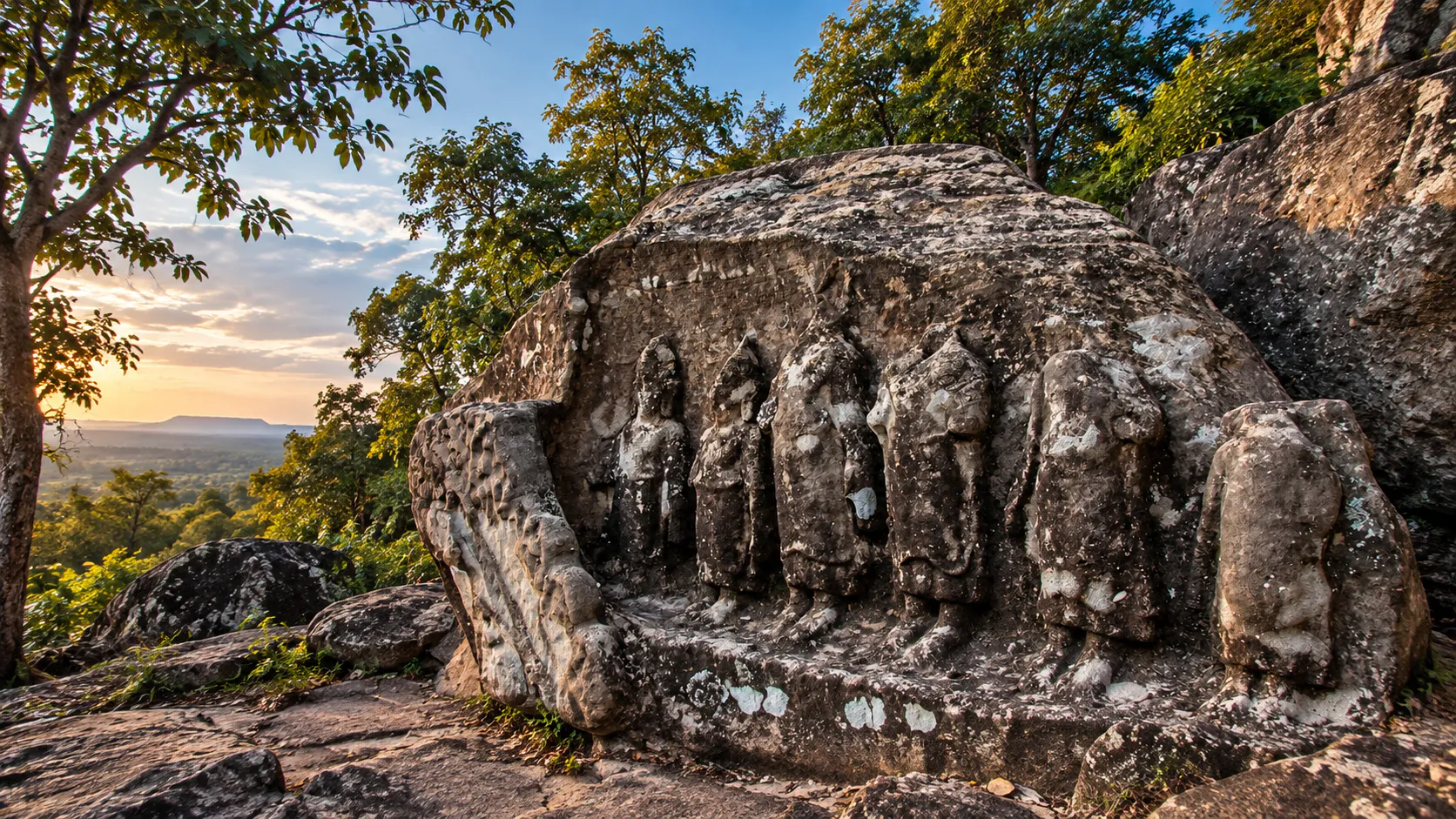
- Later sculptural and artistic influences (approx. 15th–18th Buddhist centuries in the local historical sequence). At Tham Phra, stone surfaces were modified to represent religious figures.
- Lan Xang / Lao influence
- Around the 22nd–23rd Buddhist centuries, smaller Buddha images and architectural traces reflect connections with the wider Lao cultural sphere.
The site records layers of cultural change rather than a single civilization — an important reminder that northeastern Thailand has historically been connected to cultural networks beyond modern state boundaries.
Ho Nang Usa
The Icon of Phu Phrabat · หอนางอุษา
If one image represents Phu Phrabat around the world, it is almost certainly Ho Nang Usa.
The structure stands on top of a naturally formed mushroom-like sandstone rock. At first glance it looks like a small stone tower — but its origin is more complicated. The underlying rock formation is natural. Humans subsequently modified the site and installed Sīma stones around it.
Natural geology · Human construction · Buddhist sacred boundary
The name is connected to the local legend of Usa and Baros. The legend should not be confused with the archaeological interpretation of the site. Archaeological evidence tells us about rock formations, human modification, Sīma stones and religious use. The story of Usa and Baros belongs to the later local cultural imagination that gave many monuments their names.
Kou Nang Usa
Kou Nang Usa is another important feature whose name is also connected with the Usa–Baros legend. Like Ho Nang Usa, it demonstrates how local communities have interpreted the ancient landscape through storytelling. Archaeological significance lies in the physical remains and their context rather than in the literal historical existence of the legendary characters.
The Legend of Usa and Baros
Local place names reflect characters and locations from the story, including Ho Nang Usa, Kou Nang Usa, Usa’s Well, Wat Louk Koei, Wat Phor Ta and Thao Baros’s Horse Stable. The Fine Arts Department explicitly explains that local people used the legend to name and interpret many of the ancient structures.
Legend vs. archaeology
- Archaeological layer
- Prehistoric paintings, natural rock shelters, modified formations, Sīma stones, Buddhist remains and later artistic influences.
- Cultural storytelling layer
- The Usa–Baros legend provides names and narrative meaning — part of the cultural history of the site, not archaeological proof that Usa and Baros were historical people.
This distinction makes the ThailandLover article more credible. The legend is cultural memory, not archaeological proof.
The Most Important Places to See
- 1. Ho Nang Usa
- The iconic mushroom-shaped rock with a small human-modified structure and surrounding Sīma stones — the clearest example of natural rock transformed into sacred space.
- 2. Tham Phra
- A large natural rock shelter modified for religious use, with carved religious imagery. Shows the transition from natural shelter to religious monument.
- 3. Tham Wua–Tham Khon
- Natural shelter associated with prehistoric paintings of animals and people — strong evidence of prehistoric human activity.
- 4. Non Sao Ae
- Prehistoric rock-art area with geometric and figurative designs across Non Sao Ae 1 and 2 — demonstrating variety and possibly different periods of painting.
- 5. Kou Nang Usa
- Monument associated with the local Usa–Baros storytelling tradition.
- 6–8. Wat Louk Koei, Wat Phor Ta & Thao Baros’s Horse Stable
- Sites whose modern names derive from the Usa–Baros legend — useful for understanding the relationship between archaeology and local folklore.
Tham Phra
The original formation was a large natural rock shelter created by enormous sandstone blocks. People subsequently modified the rock to create a larger chamber and carved sculptural religious imagery — the same fundamental process seen throughout Phu Phrabat: natural shelter → human modification → sacred space.
Tham Wua–Tham Khon
Formed beneath large overlapping sandstone formations, this shelter provided protection from sun and rain. On the eastern side, prehistoric paintings include human and animal imagery — the site was named according to the images found there.
Non Sao Ae
Paintings include red linear designs, geometric patterns, circular motifs, animal-like forms and later painted figures in other colours. Some imagery appears to belong to different periods — rock surfaces were not necessarily used once and then abandoned forever.
Table rocks
Some sandstone formations resemble giant stone tables: harder sandstone survives as an upper layer while softer layers underneath erode more quickly. From a distance it can look almost architectural — but the original form is geological. This is one of the best places in Thailand to explain how erosion can create structures that look deliberately built.
Why Phu Phrabat Became World Heritage
UNESCO inscribed the property under two criteria:
- Criterion (iii)
- Exceptional testimony to a cultural tradition associated with the Sīma stone tradition of the Dvaravati period.
- Criterion (v)
- An outstanding example of the interaction between human culture and the natural environment — particularly the transformation of natural rock shelters into sacred spaces.
UNESCO recognizes the property as a cultural landscape rather than merely a collection of monuments.
The UNESCO property has two components
This is an important detail often omitted from travel articles. The World Heritage property is a serial property:
- Component 1
- The Phu Phrabat Historical Park
- Component 2
- The Sīma Cultural Site at Wat Phra Phuthabat Buaban
The two locations are geographically separate but form one cultural heritage property because they collectively demonstrate the Sīma tradition and associated sacred landscape. Do not describe Wat Phra Phuthabat Buaban as physically inside Phu Phrabat Historical Park.
In one sentence: Phu Phrabat is a UNESCO World Heritage cultural landscape because it preserves an exceptional relationship between prehistoric rock-art sites, natural sandstone formations transformed into sacred spaces, and the Sīma stone tradition of the Dvaravati period.
A Timeline of Phu Phrabat
- More than 2,000–3,000 years ago
- Prehistoric communities used natural rock shelters; rock paintings were created.
- Dvaravati period (approx. 7th–11th centuries CE)
- Buddhist religious practices associated with the landscape; shelters modified; Sīma stones installed.
- Later historical periods
- Khmer-related artistic influences; some rock surfaces modified for religious imagery.
- Lan Xang / Lao influence
- Additional Lao/Lan Xang artistic and religious influences.
- 1935
- Officially registered as an archaeological monument under the historical name Phra Phutthabat Buabok.
- 1981
- Fine Arts Department registered and defined the archaeological area under the national heritage framework.
- 1989
- Development of Phu Phrabat Historical Park began as a formal Fine Arts Department project.
- 26 June 1992
- Phu Phrabat Historical Park officially opened; ceremony presided over by HRH Princess Maha Chakri Sirindhorn.
- 1 April 2004
- Placed on Thailand’s Tentative List for UNESCO World Heritage.
- 27 July 2024
- UNESCO inscribed the property as a World Heritage cultural landscape under criteria (iii) and (v).
Forest, Plants and Ecology
The historical park exists within a forested mountain environment. The Fine Arts Department describes generally open forest with native hardwood vegetation. Trees, rock, shadows and open sandstone surfaces create the atmosphere that makes Phu Phrabat visually distinctive.
Seasonal flowering plants have been highlighted in the park, including Dendrobium orchids, Gmelina and related local flowering plants, Siamese wild Himalayan cherry-type seasonal flowering, white Cratoxylum, Bauhinia relatives and other native plants. Flowering periods vary — ThailandLover avoids promising that a particular flower will bloom on an exact date.
The cultural landscape consists of rock, forest, water, human activity, religious practice and archaeological remains — elements that cannot be completely separated.
A Visit Is a Walk Through Time
- Stop 1 — Natural sandstone
- Geological history
- Stop 2 — Prehistoric rock paintings
- Human activity
- Stop 3 — Modified rock shelters
- Religious transformation
- Stop 4 — Sīma stones
- Dvaravati Buddhist landscape
- Stop 5 — Later religious remains
- Continuing cultural use
- Stop 6 — Usa–Baros place names
- Living cultural memory
Four questions at every monument
- What did nature create? Look at the sandstone.
- What did prehistoric people do? Look for paintings and occupation evidence.
- What did later communities change? Look for carved rock, structures and Sīma stones.
- What story did later generations attach to it? Look at names connected to Usa and Baros.
Visitor Information
- Opening Hours
- Daily 08:30–16:30 (verify before travel)
- Thai Admission
- THB 20 (current Fine Arts Department listing)
- Foreign Admission
- THB 120 (current Fine Arts Department listing)
- Payment
- Cash only (as currently stated)
- Guides
- Thai- and English-language interpretation available
- Shuttle
- Electric shuttle toward the Ho Nang Usa area (availability may vary)
- Phone
- +66 42 219 837 / +66 42 219 838
- Recommended Visit
- 3–4 hours comfortable; half day or more for deep cultural visits
Because admission fees and operational arrangements can change, visitors should verify the latest information before travelling.
How much time do you need?
- Quick visit — 1.5–2 hours
- Principal monuments.
- Comfortable visit — 3–4 hours
- Ho Nang Usa, rock shelters, prehistoric paintings, major features, photography and interpretation.
- Deep cultural visit — half day or more
- Best for history, archaeology, geology, photography and cultural travellers.
Best time to visit
Phu Phrabat can be visited year-round. The cool season is generally comfortable for walking. In the hot season, start earlier and carry water — exposed sandstone can become hot. In the rainy season the forest becomes greener and more atmospheric, but rock surfaces may be slippery.
Because the park currently closes at 16:30, do not plan a sunset visit inside the park unless the official operating schedule has specifically changed. Morning offers softer light, cooler temperatures and clearer interpretation.
Accessibility
The electric shuttle can reduce walking to the Ho Nang Usa area. However, expect uneven ground, stone surfaces, steps, slopes, forest paths and exposed rock. Visitors with mobility limitations should contact the historical park in advance.
What to bring
- Comfortable walking shoes
- Drinking water and sun protection
- Hat and light rain protection
- Camera and insect protection
- Small backpack
Photography & Responsible Travel
Phu Phrabat is one of Thailand’s most distinctive archaeological photography locations. The strongest theme is scale and contrast — natural rock, small human structure, Sīma stones and forest vegetation together.
When photographing Ho Nang Usa, show natural rock, the small human structure and the surrounding landscape — not as if it were a conventional temple. The contrast between the enormous natural base and the relatively small human-built element is the entire story.
Do not
- Touch rock paintings or lean against ancient surfaces
- Climb monuments or sit on protected archaeological structures
- Move stones or place objects on Sīma stones
- Use chalk, powder, smoke or fire for photographs
- Collect rocks or pick plants
- Enter restricted areas or approach unstable edges
Look, photograph, do not touch. Prehistoric pigments are extremely vulnerable to moisture, abrasion, skin oils, dust and repeated human contact.
Stay on designated paths, keep noise low, respect religious objects, follow staff instructions and dispose of waste properly. Visitors are temporarily entering an archaeological landscape — the goal is to preserve the relationship between the landscape and its archaeological evidence.
Suggested ThailandLover Routes
Half-day route
- Visitor centre — UNESCO status, archaeology, geology, site map
- Ho Nang Usa — natural rock and human modification
- Sīma stones — where the UNESCO story becomes clear
- Tham Phra — religious modification and sculpture
- Tham Wua–Tham Khon — prehistoric dimension
- Non Sao Ae — rock paintings and geometric imagery
- Forest landscape — monuments and vegetation together
- Return — connect geology + archaeology + religion + folklore
Full-day cultural route
Morning: Phu Phrabat Historical Park. Midday: local lunch in Ban Phue or surrounding communities. Afternoon: continue to Wat Phra Phuthabat Buaban, the second component of the UNESCO World Heritage property — so visitors understand the property as a whole rather than only the famous Ho Nang Usa landmark.
Who Will Love Phu Phrabat
- History lovers
- Evidence from prehistory through Dvaravati, later regional influences, Lan Xang and modern conservation.
- Archaeology lovers
- Rock art, shelter adaptation, Sīma stones and archaeological context — the Sīma tradition is arguably more important than the famous Ho Nang Usa photograph.
- Geology lovers
- Rock structure → erosion → natural shelter → human adaptation → cultural monument within one location.
- Families
- Ask: “Which part of this monument did nature create, and which part did people change?”
- Photographers
- Include a person for scale, a Sīma stone, natural rock, small human structure and forest vegetation.
- Cultural travellers
- Religion, landscape, archaeology, folklore, local identity and conservation in one place.
SEE · UNDERSTAND · FEEL · RESPECT
- SEE
- The rocks. The paintings. The Sīma stones. Ho Nang Usa. The forest.
- UNDERSTAND
- How geology shaped the landscape; how prehistoric people used it; how Dvaravati communities created sacred boundaries; how later generations continued to interpret it.
- FEEL
- The quietness beneath the sandstone shelters; the scale of the rocks; the mystery of paintings whose original meanings are not completely known; the sense of time layered into one landscape.
- RESPECT
- The archaeology. The sacred landscape. The prehistoric paintings. The Sīma stones. The forest. The communities surrounding the site.
Phu Phrabat is not simply a place to see ancient things. It is a place to understand how people and landscape became part of the same history.
ThailandLover Travel Summary
- Destination
- Phu Phrabat Historical Park
- Province / District
- Udon Thani · Ban Phue
- Region
- Isan / Northeastern Thailand
- Mountain Range
- Phu Phan Range
- Elevation
- Approximately 320–350 metres
- Signature Monument
- Ho Nang Usa
- UNESCO
- 27 July 2024 · Cultural Landscape · criteria (iii), (v)
- Opened
- 26 June 1992
- Hours / Admission
- 08:30–16:30 · THB 20 Thai / THB 120 foreign (verify)
- Recommended Visit
- 3–4 hours
- Travel Style
- History · Archaeology · Geology · Culture · UNESCO · Nature · Photography
Frequently Asked Questions
- Is Phu Phrabat a national park?
- No. Phu Phrabat Historical Park is a historical and archaeological park managed by the Fine Arts Department. It should not be described as Phu Phrabat National Park.
- Is Phu Phrabat a UNESCO World Heritage Site?
- Yes. The property “Phu Phrabat, a testimony to the Sīma stone tradition of the Dvaravati period” was inscribed on 27 July 2024.
- What type of UNESCO site is it?
- A cultural landscape under criteria (iii) and (v).
- Why is Phu Phrabat famous?
- Unusual sandstone formations, prehistoric rock paintings, modified rock shelters, Dvaravati Sīma stones, Buddhist sacred landscapes, Ho Nang Usa and the Usa–Baros local legend.
- How old are the rock paintings?
- Generally associated with human activity around 2,000–3,000 years ago; individual paintings may represent different periods.
- How old are the Sīma stones?
- Associated with the Dvaravati period, approximately the 7th–11th centuries CE.
- What is Ho Nang Usa?
- The famous mushroom-shaped sandstone formation with a small human-modified structure on top and Sīma stones around it.
- Is Usa and Baros a true historical story?
- It is a local legend and storytelling tradition. Treat archaeological evidence separately from the legend.
- Can I see prehistoric paintings?
- Yes — at several rock shelters. Do not touch painted surfaces. UNESCO identifies 47 rock shelters with rock paintings within the nominated cultural landscape.
- Is Wat Phra Phuthabat Buaban inside the historical park?
- No. It is a separate site and the second component of the UNESCO serial property.
- How long should I spend?
- Approximately 3–4 hours for a comfortable visit; longer for deep cultural exploration.
- Is it suitable for children and photographers?
- Yes — educational for families (with supervision on uneven terrain) and highly distinctive for photographers of sandstone, forest, Sīma stones and dramatic natural forms.
- What is the best time to visit?
- Year-round. Cooler periods are generally pleasant for walking. Rainy season is greener but sandstone may be slippery.
Related Destinations
- Phu Phan National Park
- A separate natural protected area in the Phu Phan mountain system — not a subdivision that contains Phu Phrabat Historical Park.
- Pha Taem National Park
- Another Isan sandstone landscape with prehistoric rock paintings — similar geology, different archaeological story.
- Phu Pha Thoep National Park
- Sandstone formations in Mukdahan — geological cousins, without Phu Phrabat’s Sīma cultural landscape.
- Nature & Parks
- More protected landscapes and heritage places across ThailandLover’s collection.
Map & Location
Mueang Phan Subdistrict, Ban Phue District, Udon Thani Province, Thailand