



National Park · Uttaradit
Ton Sak Yai National Park
อุทยานแห่งชาติต้นสักใหญ่
Ancient Teak · Mountain Wilderness · Waterfalls · Caves · Phu Miang
Nam Pat · Uttaradit · Northern Thailand
In the mountains of northern Thailand, a single ancient teak — Mahesak — has become the symbol of an entire living forest.
A Tree That Remembers the Forest
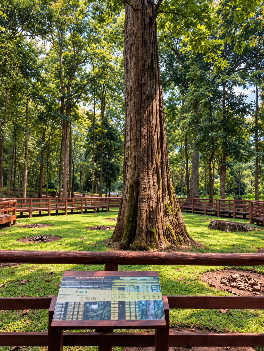
Known as Mahesak, this enormous teak stands within Ton Sak Yai National Park in Nam Pat District, Uttaradit.
Estimated at around 1,500 years old, Mahesak is recognised by Thai government sources as the world’s largest living teak tree.
But the tree is only the beginning. Beyond Mahesak lies mixed deciduous forest, dry evergreen forest, mountain streams, waterfalls, caves and high peaks — including Phu Miang at approximately 1,656 metres.
Ancient forest, mountain water and one extraordinary living tree — together.
At a Glance
- ~1,500 years
- Estimated age of Mahesak, the giant teak.
- 518.80 km²
- Official park area — 324,240.80 rai.
- 1,656 m
- Phu Miang — the park’s high mountain.
- Park No. 103
- Established 4 December 2003.
- 2012
- Renamed from Khlong Tron National Park.
- Official Name
- Ton Sak Yai National Park
- Thai Name
- อุทยานแห่งชาติต้นสักใหญ่
- Province
- Uttaradit
- Main Districts
- Nam Pat, Mueang Uttaradit, Tha Pla and Thong Saen Khan
- Former Name
- Khlong Tron National Park
- National Park No.
- 103
- Established
- 4 December 2003
- Renamed
- 12 July 2012
- Official Area
- 324,240.80 rai / 518.80 km²
- Highest Mountain Area
- Phu Miang — approximately 1,656 m
- Signature Landmark
- Mahesak, the giant teak tree
- Landscape
- Mixed deciduous, dry evergreen, hill evergreen and pine forest
- Famous For
- Mahesak, Khlong Tron, Huai Khom, Huai Sai, caves and Phu Miang
- Best For
- Nature, photography, hiking, waterfalls, camping and forest exploration
The Department of National Parks lists Ton Sak Yai at approximately 324,240.80 rai (518.80 km²), covering forest across several districts of Uttaradit.
Why Ton Sak Yai Is Special
Many national parks are known for a mountain. Others for a waterfall. Ton Sak Yai has something much older.
A living tree.
Mahesak has survived for an estimated 1,500 years — a reminder of the vast teak forests that once covered large parts of northern Thailand. The park preserves the broader ecosystem around it: mixed deciduous and dry evergreen forests, mountain streams and highland habitats.
The tree is the symbol of a living forest — not an isolated monument.
The Story of Mahesak
Thailand’s giant living teak
The tree known as Mahesak was reportedly discovered around 1927, then protected as the centrepiece of the Ton Sak Yai Forest Park from 1968.
Historical measurements recorded on 18 June 2000:
- 47.8 m
- Height measured in 2000.
- 10.07 m
- Trunk circumference measured in 2000.
- ~10.22 m
- More recent provincial circumference figure.
Thai government sources commonly describe Mahesak as the largest living teak tree in the world.
The Name Mahesak
On 29 September 2009, the giant teak was named “Mahesak” by Her Royal Highness Princess Maha Chakri Sirindhorn.
Earlier, on 14 January 1998, Her Majesty Queen Sirikit visited the tree and gave guidance that it should be carefully maintained for as long as possible. Forestry and national-park authorities then established a conservation committee.
The park continues to protect Mahesak through careful soil management and controlled visitor movement around its base.
Protecting the Giant Tree
Visitors do not walk directly on the soil at the tree’s base. A raised wooden walkway lets you see Mahesak at close range while reducing compaction of the root zone.
Look closely. Let the tree remain untouched.
The Mahesak Forest Park Area
The area around the giant teak was historically managed as Ton Sak Yai Forest Park. Today it is the most accessible visitor experience in the national park.
- The giant Mahesak teak
- Raised viewing walkway
- Small exhibition area
- Interpretation about the tree
- Forest scenery
- Nature-study trail (~2 km)
- Visitor facilities
The trail is an easy way to explore mixed forest beyond the tree itself — shifting the visit from “see the big tree” to “understand the forest that protects it.”
From Khlong Tron to Ton Sak Yai
The park’s changing identity
The protected area was originally established as Khlong Tron National Park, named for a major stream system in the forest. Surveyed from the late 1980s into the early 1990s, it became Thailand’s 103rd national park on 4 December 2003.
On 12 July 2012 it was renamed Ton Sak Yai National Park, reflecting the outstanding significance of the giant teak.
- Khlong Tron
- The mountain watershed.
- Ton Sak Yai
- The ancient teak forest.
The Khlong Tron Watershed
Mountains collect rainfall and feed streams that eventually flow toward the Nan River. Khlong Tron is a major watercourse formed by smaller forest streams — supporting wildlife, vegetation and communities downstream, and creating the park’s signature waterfalls.
Mountain → Forest → Stream → Waterfall → Nan River

The Mountains of Ton Sak Yai
Ton Sak Yai is a mountainous landscape. Important features include Phu Miang, Khao Khwam Ruea, Khao Ngang Ruea, Khao Sam Liam, Khao Yuak, Khao Thanon, Khao Daet, Khao Mai Pha, Khao Tak Bon, Khao Nam Yoi, Khao Phak Khuang and Khao Chan.
The highest area is Phu Miang at approximately 1,656 m, along the mountainous rim between Uttaradit and Phitsanulok.
Phu Miang
The high mountain of Ton Sak Yai
At about 1,656 metres, Phu Miang is dramatically different from the Mahesak visitor area. Large cliffs, mountain viewpoints and, in clear weather, views across Uttaradit and Phitsanulok toward Sirikit Dam.
The route passes through changing forest — rhododendrons, ferns, wild mountain plants, orchids and other highland species — and a sequence of waterfalls.
This is a serious trekking experience, not a casual nature walk.
The Phu Miang Trek
The summit area has limited facilities. Camping may be possible under designated conditions — carry what you need. The environment grows cooler and more exposed toward the ridge.
- Long walking distances
- Steep, uneven forest trails
- Wet conditions
- Limited facilities
- Changing temperatures
- Overnight camping readiness
- Remote surroundings
Khlong Tron Waterfall
A forest waterfall in two sections
Khlong Tron Waterfall is formed by Huai Khlong Tron. The first section has about four tiers (~20 m combined). A second fall farther along reaches about 30 m.
Access is on foot — different from the easy Mahesak area. That contrast is part of the park’s character.
Huai Khom Waterfall
Near Ban Huai Khom, this is a sequence of three falls: roughly 15 m, then two tiers totalling ~15 m about 200 m upstream, then a ~20 m single drop farther on.
About 5 km from Ban Huai Khom — vehicles cannot reach the falls. A remote forest experience, not a roadside stop.
Huai Sai Waterfall
A single-drop fall of about 35 metres on Huai Sai, associated with the Khao Khwam Ruea area. Quieter forest setting; volume changes with rainfall. Follow local safety instructions before approaching the water.
Huai Niam & Other Waterfalls
Official park information also identifies Huai Niam and Mon Kaew among the park’s stream attractions. Accessibility varies; some routes need forest walking.
Present them as nature attractions within a large protected landscape — not as same-day stops from one entrance.
Caves of Ton Sak Yai
- Tham Chan
- Tham Chedi
- Tham Suea Dao
- Tham Pha Tang
Forest Ecosystems
- Mixed deciduous
- Teak, afzelia, padauk, lagerstroemia and related species — brighter and more open in the dry season as leaves fall.
- Dry evergreen
- Hopea, dipterocarps, yang, wild mango and denser year-round canopy where moisture is higher.
- Hill evergreen
- Cooler, wetter montane plants, ferns and mosses around Phu Miang and higher ridges.
- Pine forest
- Higher-elevation pine communities in the park’s official vegetation record.
Wildlife & Birdlife
Species documented in official descriptions include serow, bear, sambar, muntjac, mouse deer, wild boar, clouded leopard, fishing cat, civets, slow loris, porcupine, squirrels, barking deer, reptiles and numerous birds.
Serow and clouded leopard signal the ecological importance of remote mountain forest. Sightings are unpredictable — wildlife is often present without being visible.
For birds: songbirds, woodpeckers, drongos, bulbuls, pigeons, raptors and water-associated species. Move slowly. Bring binoculars if observation is a priority.
Seasons & When to Visit
- October – February · Cool
- Higher mountains cool down. Comfortable for hiking and forest exploration; pleasant mornings.
- March – April · Hot
- Lower elevations heat up; deciduous forest opens as leaves fall. Start early and carry water on longer walks.
- May – September · Rainy
- Stronger waterfalls and deep green forest. Trails can be slippery; access to falls and mountain routes may change.
- For Mahesak
- Visitable year-round, subject to current park conditions.
- For waterfalls
- Rainy season generally offers stronger flow.
- For hiking
- Cooler months are more comfortable; trail access follows the park schedule.
- For Phu Miang
- Trekking season is controlled and may close annually — check with the park.
Ton Sak Yai for Hikers
- Easy · Mahesak
- Giant teak → forest trail → visitor area. Suitable without a major trek.
- Adventure · Phu Miang
- Mountain trail → waterfalls → high forest → summit. For experienced hikers only.
Two sides of the same protected landscape — never present them as equivalent.
Camping
- Zone 1
- Park Headquarters — accommodation, tents and camping area.
- Zone 2
- Ton Khon Nun Ranger Station — about 45 km from headquarters; accommodation and camping.
How to Get There
Ton Sak Yai National Park is in Nam Pat District, Uttaradit.
- From Phitsanulok
- Phitsanulok–Uttaradit route, then Highway 1047 toward the park — about 53 km on 1047 from the relevant junction.
- From Uttaradit / Sirikit Dam
- Uttaradit–Sirikit Dam–Nam Pat route, then Highway 1047 — about 9 km on 1047 from the junction.
Confirm navigation locally before travelling into remote areas.
Visiting Mahesak
A visit does not require a strenuous hike. Allow time to:
- 1
- Walk to the giant teak.
- 2
- Follow the raised walkway.
- 3
- Read the interpretation panels.
- 4
- Visit the exhibition area.
- 5
- Walk the nature-study trail.
- 6
- Explore the surrounding forest.
The experience deepens when the tree is seen in its ecological context — a survivor of an ancient forest landscape, not a botanical-garden specimen.
Responsible Travel
Mahesak is a living organism. Help protect it.
- Do not touch the trunk unnecessarily
- Do not climb the tree
- Do not step off the raised walkway
- Do not damage roots or soil
- Do not carve names into the bark
- Do not collect leaves, seeds or branches
- Do not leave rubbish
In the wider mountain forest:
- Stay on designated routes
- Do not feed or approach wildlife
- Do not collect plants
- Do not enter caves without permission
- Do not leave food waste or use soap in streams
- Carry your rubbish out
The less evidence visitors leave behind, the better.
Uttaradit’s Forest Heritage
Uttaradit has a long relationship with teak. Mahesak has become one of the province’s natural symbols — and the story is no longer about extracting teak. It is about understanding what remains: conservation, heritage and ecological value.
Why Visit Ton Sak Yai?
Few travel experiences let you stand beside a tree that has survived roughly fifteen centuries. The park also offers ancient teak forest, mountains, waterfalls, caves, highland vegetation, wildlife, remote hiking and mountain viewpoints.
- Ancient teak
- Mountain forests
- Waterfalls
- Caves
- Highland vegetation
- Wildlife
- Remote hiking
- Forest streams
- Mountain viewpoints
ThailandLover Travel Guide
- Best for
- Nature lovers · Photographers · Forest explorers · Hikers · Campers · Wildlife enthusiasts
- Travel style
- Nature + Heritage + Hiking + Wildlife
- Don’t miss
- Mahesak · Nature trail · Khlong Tron · Huai Khom · Huai Sai · Phu Miang
- Best experience
- Start with Mahesak, then the surrounding forest — plan Phu Miang as a separate mountain trek.
- Travel character
- Ancient · Wild · Quiet · Forested · Remote
Essential Information
- Park
- Ton Sak Yai National Park · อุทยานแห่งชาติต้นสักใหญ่
- Location
- Nam Pat District, Uttaradit, Thailand
- Former name
- Khlong Tron National Park
- Established
- 4 December 2003 · National Park No. 103
- Renamed
- 12 July 2012
- Official area
- 324,240.80 rai / 518.80 km²
- Signature landmark
- Mahesak — ancient giant teak (~1,500 years)
- Historical measurement
- 47.8 m height and 10.07 m circumference (18 June 2000)
- Recent circumference
- Approximately 10.22 m (provincial figure)
- High mountain
- Phu Miang — approximately 1,656 m
- Main waterfalls
- Khlong Tron · Huai Khom · Huai Sai · Huai Niam · Mon Kaew
- Caves
- Tham Chan · Tham Chedi · Tham Suea Dao · Tham Pha Tang
- Forest types
- Mixed deciduous · Dry evergreen · Hill evergreen · Pine
- Main visitor area
- Mahesak / Ton Sak Yai Forest Park area
- Nature trail
- Approximately 2 km
- Park contact
- +66 89 958 6759
Frequently Asked Questions
- What is Ton Sak Yai National Park?
- A mountain forest park in Uttaradit, best known for Mahesak — an ancient living teak — plus Phu Miang, waterfalls, caves and mixed forest. Established 2003 as Khlong Tron; renamed Ton Sak Yai in 2012.
- Where is it, and how large is it?
- Nam Pat, Mueang Uttaradit, Tha Pla and Thong Saen Khan. About 324,240.80 rai, or 518.80 km².
- What is Mahesak?
- The park’s giant teak, named in 2009 by HRH Princess Maha Chakri Sirindhorn. Measured in 2000 at about 47.8 m height and 10.07 m circumference; later provincial circumference about 10.22 m.
- When is the best time to visit?
- Cool season for hiking; rainy season for stronger waterfalls; Mahesak year-round subject to park conditions. Confirm Phu Miang dates with the park.
- Is Phu Miang hard?
- Yes — a serious remote trek at about 1,656 m, not equivalent to the easy Mahesak area.
- How do I get there?
- Highway 1047 from the Phitsanulok–Uttaradit or Sirikit Dam–Nam Pat approaches. About 53 km or 9 km on 1047 depending on the junction.
- Can I camp there?
- Yes — Zone 1 at headquarters and Zone 2 at Ton Khon Nun Ranger Station. Check the DNP reservation system.
More Parks Near Uttaradit & the Nan River
- Si Nan National Park
- Southern Nan mountain-and-river country — Doi Samer Dao, Pha Chu and the Nan River corridor toward Pak Nai.
- Lam Nam Nan National Park
- Reservoir shores and mountain forest linking Nan and Uttaradit.
- Phu Soi Dao National Park
- Highland pine and meadow landscape on the Uttaradit–Phitsanulok rim.
- Namtok Chat Trakan National Park
- Multi-tier waterfall country in Phitsanulok’s mountain forest.
Location
Find Ton Sak Yai National Park
Nam Pat, Uttaradit · Mahesak visitor area · Highway 1047 approaches