



86th National Park · Krabi
Than Bok Khorani National Park
อุทยานแห่งชาติธารโบกขรณี
Limestone, Emerald Streams, Caves & Andaman Islands
Ao Luek · Mueang Krabi · Southern Thailand
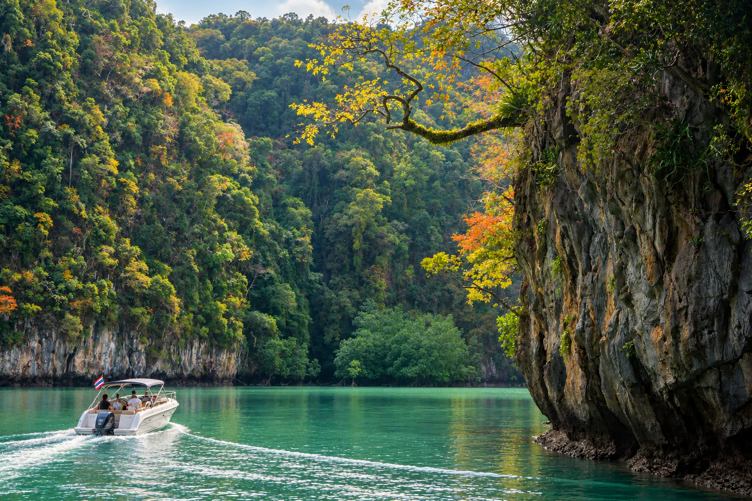
Evergreen forest, karst, underground water, mangroves, prehistoric rock art and islands scattered across the Andaman Sea — one protected landscape north of Krabi.
Where Forest Meets the Andaman
Hidden in the landscapes of Ao Luek, north of Krabi, Than Bok Khorani National Park (อุทยานแห่งชาติธารโบกขรณี) brings together several sides of southern Thailand in one protected area: evergreen forest, limestone karst, underground waterways, mangroves, caves, prehistoric rock art and islands scattered across the Andaman Sea.
It is a destination where freshwater streams meet limestone mountains and coastal ecosystems. A visit can begin with an emerald-green forest stream at the park headquarters and continue toward limestone caves, mangrove waterways and offshore islands such as Ko Hong.
Unlike a destination built around a single famous viewpoint, Than Bok Khorani is a landscape of connected natural and cultural environments.
At a Glance
- ~104 km²
- Protected area — approximately 65,000 rai.
- 86th
- Thailand’s national park, designated in 1998.
- 2 districts
- Ao Luek and Mueang Krabi.
- Andaman
- Forest, mangrove and offshore limestone islands.
- Rock art
- Prehistoric paintings at Tham Phi Hua To.
- Official Name
- Than Bok Khorani National Park
- Thai Name
- อุทยานแห่งชาติธารโบกขรณี
- Province
- Krabi
- Main Districts
- Ao Luek and Mueang Krabi
- Region
- Southern Thailand
- Coast
- Andaman Sea
- Protected Area
- Approximately 104 km² / 65,000 rai
- National Park
- Thailand’s 86th national park, designated in 1998
- Landscape
- Limestone karst, evergreen forest, mangrove, freshwater streams, caves and islands
- Known For
- Emerald pools, limestone caves, prehistoric rock paintings and Ko Hong
- Best For
- Nature, photography, kayaking, swimming, archaeology and coastal exploration
Why Than Bok Khorani Is Special
Than Bok Khorani is not simply a forest park with a waterfall. Its character comes from the relationship between limestone, water and the sea.
Rainwater has shaped the area’s limestone landscape over long periods, producing caves, underground waterways, sinkholes, cliffs and distinctive limestone formations. Freshwater flows through the forest before continuing toward the coastal environment, while mangrove forests occupy parts of the shoreline and estuarine areas.
Farther offshore, the park extends into the Andaman Sea and includes a group of limestone islands, creating a remarkable transition from forest to freshwater, mangrove and marine ecosystems within the same protected landscape.
This combination gives Than Bok Khorani a different atmosphere from Krabi’s better-known beach destinations.

Than Bok Khorani Emerald Stream
ธารโบกขรณี · the easiest introduction
The area around the park headquarters is the most accessible part of the national park and is named after the beautiful Than Bok Khorani stream.
The stream flows through a forested limestone landscape, forming a series of pools and cascades surrounded by tropical vegetation. The water has an emerald appearance in places, creating one of the most recognizable scenes in Ao Luek.
The stream originates from the limestone hills around Khao Tham Nam Phut and Khao Tham Phet before flowing through the Ao Luek area. The park’s official information describes the watercourse as passing through the mountain landscape and eventually reaching the sea.
For visitors, this is one of the easiest places to experience the park without committing to a long excursion. The atmosphere is particularly appealing in the morning, when the forest is shaded and the surrounding vegetation frames the water.
What to do here
- Walk through the forest and around the stream
- Enjoy the scenery and freshwater pools
- Swim only in designated areas
- Photograph the limestone-and-forest landscape
- Take a slower nature walk rather than treating the site as a quick photo stop
Limestone Karst
The landscape behind the scenery
One of the defining features of Than Bok Khorani is its karst landscape. Parts of the park consist of steep limestone mountains, cliffs, underground waterways and depressions created by the dissolution of limestone. The official park description also records sinkholes and subterranean water systems.
This geological environment explains why caves are such an important part of the park. Instead of viewing the caves as isolated attractions, they can be understood as part of the same geological system that creates the park’s streams, cliffs and coastal formations.
Tham Phi Hua To
ถ้ำผีหัวโต · Phi Hua To Cave · Skull Cave
Tham Phi Hua To, commonly translated as Phi Hua To Cave or Skull Cave, is one of the most culturally significant sites associated with Than Bok Khorani National Park.
The cave is known for its prehistoric rock paintings, which include human and animal forms, hand representations and geometric or symbolic shapes. The paintings are particularly important because they provide evidence of ancient human activity in the coastal limestone landscape of Krabi.
The Department of National Parks has included Phi Hua To Cave among the caves surveyed for geological and cave-management purposes. The cave should be treated as an archaeological site rather than simply a photographic attraction.
See the cave responsibly
Ancient paintings are extremely fragile. Visitors should:
- Never touch the paintings
- Never scratch or write on cave walls
- Never remove rocks or archaeological material
- Follow designated routes
- Follow instructions from park officials and local guides
- Check the current access status before visiting
Cave conditions and access can change because of weather, geology, safety inspections and conservation requirements.
Tham Lot
ถ้ำลอด · a passage through limestone
Tham Lot is another important limestone cave within the park’s landscape. The cave is associated with a natural passage through limestone and contains formations created by water over geological time.
The experience is different from visiting the emerald stream at the park headquarters. Access to the cave area generally forms part of a boat-based or water-based excursion in the Ao Luek coastal landscape rather than a simple walk from the park’s main entrance.
Tham Lot and Phi Hua To are often visited together as part of an Ao Luek cave and mangrove excursion. Because water levels, tides and weather affect access to caves and coastal passages, visitors should follow local operator and park safety instructions.
Ancient Rock Art
One of Than Bok Khorani’s most fascinating characteristics is the concentration of prehistoric rock art within its limestone landscape. The paintings depict forms including:
- Human figures
- Animals
- Hands
- Boats or water-related forms
- Geometric and symbolic shapes
The existence of these paintings suggests that the limestone caves and coastal environment were connected with the activities, beliefs or cultural practices of people living in the region in the distant past.
The Department of National Parks describes many of the paintings as ancient paintings associated with ritual use, while archaeological interpretation of individual images and their exact meanings requires specialist study.
People were already interacting with the same limestone, waterways and coastal environment thousands of years ago.
Mangrove Forests
The park’s coastal ecosystem
Mangrove forests occur in areas including Khao Tham Lot Tai, Ao Nam, Laem Sak and parts of the coastal landscape. The park’s official information records species such as Rhizophora mangroves, Xylocarpus, Bruguiera and Avicennia.
Mangroves are essential coastal habitats. Their roots provide shelter for aquatic organisms while helping stabilize shorelines and connect terrestrial and marine ecosystems.
The mangrove environment is best experienced slowly — particularly by boat or kayak — where narrow waterways reveal limestone cliffs, roots, tidal channels and forest edges from a different perspective.
Khao Karos and the Ao Luek Coast
The broader Ao Luek area around Than Bok Khorani is characterized by dramatic limestone formations rising from mangrove and coastal waters. Khao Karos is one of the area’s distinctive limestone landscapes and can be explored through boat and kayak routes that pass through mangroves, cliffs and waterways.
This type of excursion offers a different side of Krabi from the classic beach-and-island itinerary. Instead of open beaches, the scenery becomes a continuous sequence:
Mangrove → Limestone → Waterway → Cave → Andaman Sea
The landscape changes continuously as the boat moves through the channels. Local boat operators are particularly valuable here because tides and water conditions influence the best routes and access to certain areas.
Ko Hong
เกาะห้อง · the Hong Islands · Ko Lao Bi Le
One of the best-known marine destinations associated with Than Bok Khorani National Park is Ko Hong, also known as Ko Lao Bi Le. The Hong Islands are a group of limestone islands in the Andaman Sea. Ko Hong is the largest and most recognizable island in the group.
Its landscape combines:
- Limestone cliffs
- Clear Andaman waters
- Sandy beaches
- Coral reef environments
- Snorkelling areas
- Marine ecosystems
- A distinctive island-and-lagoon landscape
Tourism Authority of Thailand describes Ko Hong as a destination suited to visitors interested in nature, swimming and snorkelling. The Hong Islands are reached by boat and should be considered a separate marine excursion from the main freshwater area at the park headquarters.
This distinction is important when planning a trip.
Wildlife and Marine Life
The park contains several different ecosystems, so its biodiversity extends from forest to freshwater and marine environments. The official national park information records wildlife including:
- Wild boar
- Fishing cat
- Lesser mouse deer
- Gibbons
- Macaques
- Langurs
- Malayan porcupine
- Pangolin
- Small-clawed otter
- Squirrels and other small mammals
- Numerous bird species
The freshwater environment also supports a variety of fish. Offshore, the park’s marine area contains a range of marine organisms, including reef fish, sea stars, sea cucumbers, sea urchins, anemones, sponges and several types of coral.
Wildlife sightings are never guaranteed. The best approach is to observe quietly and allow animals to remain undisturbed.
Forests of Than Bok Khorani
The park contains several distinct vegetation communities. Together, these habitats show why Than Bok Khorani is more than a waterfall destination.
Evergreen Forest
Evergreen forest occurs around the limestone mountains and higher areas. Trees and plants recorded by the park include species such as Hopea, dipterocarps, Lagerstroemia and various palms, bamboo, ferns and orchids.
Mangrove Forest
Mangrove forest occurs around coastal mudflats, estuaries and tidal areas.
Peat Swamp
A small peat swamp occurs around the southern part of Khao Chong Lom.
Things to Do
- 1 · Explore the emerald stream
- The easiest introduction to the national park is the Than Bok Khorani stream and its forest surroundings.
- 2 · Swim in designated areas
- Swimming is possible in designated freshwater areas, subject to current park conditions and instructions.
- 3 · Walk the nature area
- The forest around the headquarters provides an easy way to experience the landscape without taking a boat excursion.
- 4 · Explore limestone caves
- Boat-based excursions can connect visitors with caves such as Tham Lot and Tham Phi Hua To.
- 5 · Discover ancient rock art
- The prehistoric paintings provide a rare cultural dimension to a natural landscape.
- 6 · Kayak through mangroves
- Mangrove waterways around Ao Luek offer an intimate way to experience limestone cliffs and coastal ecosystems.
- 7 · Visit the Hong Islands
- For a full marine experience, continue to the Hong Islands for beaches, clear water, snorkelling and limestone scenery.
- 8 · Photograph the landscape
- The scenery changes from forest streams to limestone cliffs and open Andaman waters.
When to Visit
Krabi has a tropical monsoon climate. The national park’s official information describes a rainy season extending broadly from late April through December and a drier period from around mid-January through April. February is identified as having the lowest rainfall, while April is generally the warmest month.
For travelers interested in boat trips, caves, kayaking and islands, weather and sea conditions are particularly important. The mainland freshwater area can be visited under different seasonal conditions, but heavy rain may affect water clarity, trails and access to certain outdoor areas.
- November – April
- Often more suitable for combining mainland nature with coastal and island excursions, subject to actual weather and sea conditions.
- May – October
- Expect a greater possibility of rain and changing sea conditions. The landscape can be lush, but outdoor plans should remain flexible.
Always check current park announcements and marine conditions before setting out.
How to Get There
The national park headquarters is in Ao Luek Tai Subdistrict, Ao Luek District, Krabi Province. From Krabi, travelers generally head north toward Ao Luek and continue toward the park along the Ao Luek–Laem Sak road network. The headquarters is approximately 48 kilometres from Krabi according to the national park travel information published for the area.
By car
Driving is the most flexible option because the national park and its coastal attractions are spread across a relatively large area. A typical approach from Krabi is:
Krabi → Highway 4 → Ao Luek → Route 4039 → Than Bok Khorani National Park
By local transport
Public transport and taxis are available in the wider Krabi–Ao Luek area, although reaching individual coastal attractions and boat piers may require additional local transport. For cave, mangrove and island excursions, arrangements with local boat operators are generally necessary.
Entrance Fees
According to the Department of National Parks’ published fee schedule, Than Bok Khorani National Park is in Group 3.
- Thai adult
- 60 THB
- Thai child
- 30 THB
- Foreign adult
- 300 THB
- Foreign child
- 150 THB
The national park’s fee schedule is subject to government regulations and may be revised. Boat transportation, local tours and other services may be charged separately.
Check the latest official information before your visit, particularly if planning a marine excursion.
Visitor Tips
- Wear suitable shoes
- Limestone and wet surfaces can become slippery.
- Bring drinking water
- Especially if combining the park with a longer coastal excursion.
- Protect the archaeological sites
- Never touch, scratch or mark prehistoric paintings.
- Respect the water
- Do not use soap or shampoo in natural streams.
- Do not feed wildlife
- Wild animals should remain wild.
- Reduce plastic waste
- Bring reusable drinking water where practical and take all waste with you.
- Check conditions before visiting caves
- Caves are natural environments where falling rocks, water levels, tides and weather can affect safety.
- Plan mainland and marine sections separately
- The emerald stream near the headquarters and destinations such as Ko Hong and the coastal caves are not one continuous walking route.
ThailandLover Travel Guide
- Best for
- Nature lovers, photographers, families, independent travelers, kayaking, cave exploration, archaeology and island exploration.
- Travel style
- Nature + Culture + Adventure
- Recommended duration
- A short visit can focus on the emerald stream and forest. Caves, mangroves and the Hong Islands need substantially more time and separate boat excursions.
- Don’t miss
- Than Bok Khorani emerald stream · Tham Phi Hua To · Tham Lot · mangrove waterways · Khao Karos · Ko Hong
- Travel character
- Less about checking off one landmark, more about discovering the relationship between Krabi’s limestone landscape, water, forest and sea.
Essential Information
- Park
- Than Bok Khorani National Park · อุทยานแห่งชาติธารโบกขรณี
- Address
- Ao Luek Tai, Ao Luek District, Krabi, Thailand
- Official area
- Approximately 104 km² / 65,000 rai
- Province
- Krabi, Southern Thailand
- Coast
- Andaman Sea
- National park no.
- 86, designated in 1998
- Main landscape
- Limestone karst, evergreen forest, mangrove, freshwater streams, caves and offshore islands
- Distance from Krabi
- Approximately 48 kilometres to headquarters
- Official park contact
- +66 75 681 096
- Before you go
- Check the Department of National Parks for current entrance fees, temporary closures, cave access, marine conditions and visitor regulations.
Frequently Asked Questions
- What is Than Bok Khorani National Park?
- Thailand’s 86th national park, in Ao Luek and Mueang Krabi. About 65,000 rai (104 km²) of evergreen forest, limestone karst, emerald streams, caves, prehistoric rock art, mangroves and Andaman islands including Ko Hong.
- Where is it, and how large is it?
- Headquarters is in Ao Luek Tai, Ao Luek District, about 48 kilometres north of Krabi town. The park covers approximately 104 km² and was designated in 1998.
- What can I see at headquarters?
- The emerald Than Bok Khorani stream, forest pools and cascades below the limestone hills of Khao Tham Nam Phut and Khao Tham Phet. Swim only where the park allows, and watch for slippery rock.
- What is Tham Phi Hua To?
- A cave known for prehistoric paintings of people, animals, hands and geometric shapes. Treat it as an archaeological site and check access before you go.
- Is Ko Hong the same visit as the stream?
- No. Ko Hong is a boat excursion. The stream is a mainland visit at headquarters. Tham Lot and Phi Hua To are usually reached by boat through the Ao Luek mangroves.
- When is the best time to visit?
- November to April is generally better for combining the stream with caves, kayaking and islands. May to October is greener and wetter. February is the driest month in park climate notes; April is generally the warmest.
- How do I get there, and what does it cost?
- Krabi → Highway 4 → Ao Luek → Route 4039. Group 3 fees are listed at 60 / 30 THB for Thai adults and children, and 300 / 150 THB for foreign adults and children. Boats are extra, and fees can change. Contact the park on +66 75 681 096.
More of Krabi’s Wild Parks
- Khao Phanom Bencha National Park
- Krabi’s highest mountain rainforest — waterfalls and forest close to town, a terrestrial counterpart to this karst-and-sea park.
- Hat Noppharat Thara–Mu Ko Phi Phi National Park
- The coastal Krabi most visitors know — beaches, islands and the Andaman Sea.
- Mu Ko Lanta National Park
- Twenty-five Andaman islands, coral, mangroves and Ko Rok, farther down the Krabi coast.
- Ao Phang Nga National Park
- Karst islands and mangrove seascapes just west of Krabi.
Location
Find Than Bok Khorani National Park
Ao Luek Tai, Ao Luek District, Krabi · about 48 km north of Krabi town