


National Park · Phayao & Chiang Rai
Phu Sang National Park
อุทยานแห่งชาติภูซาง
Where a Warm Waterfall Flows Through the Northern Mountains
Phayao & Chiang Rai · Northern Thailand
Warm water, limestone caves, wild mountains and the quieter borderlands of Northern Thailand — all connected by one remarkable landscape.
A Warm Waterfall in a Northern Forest
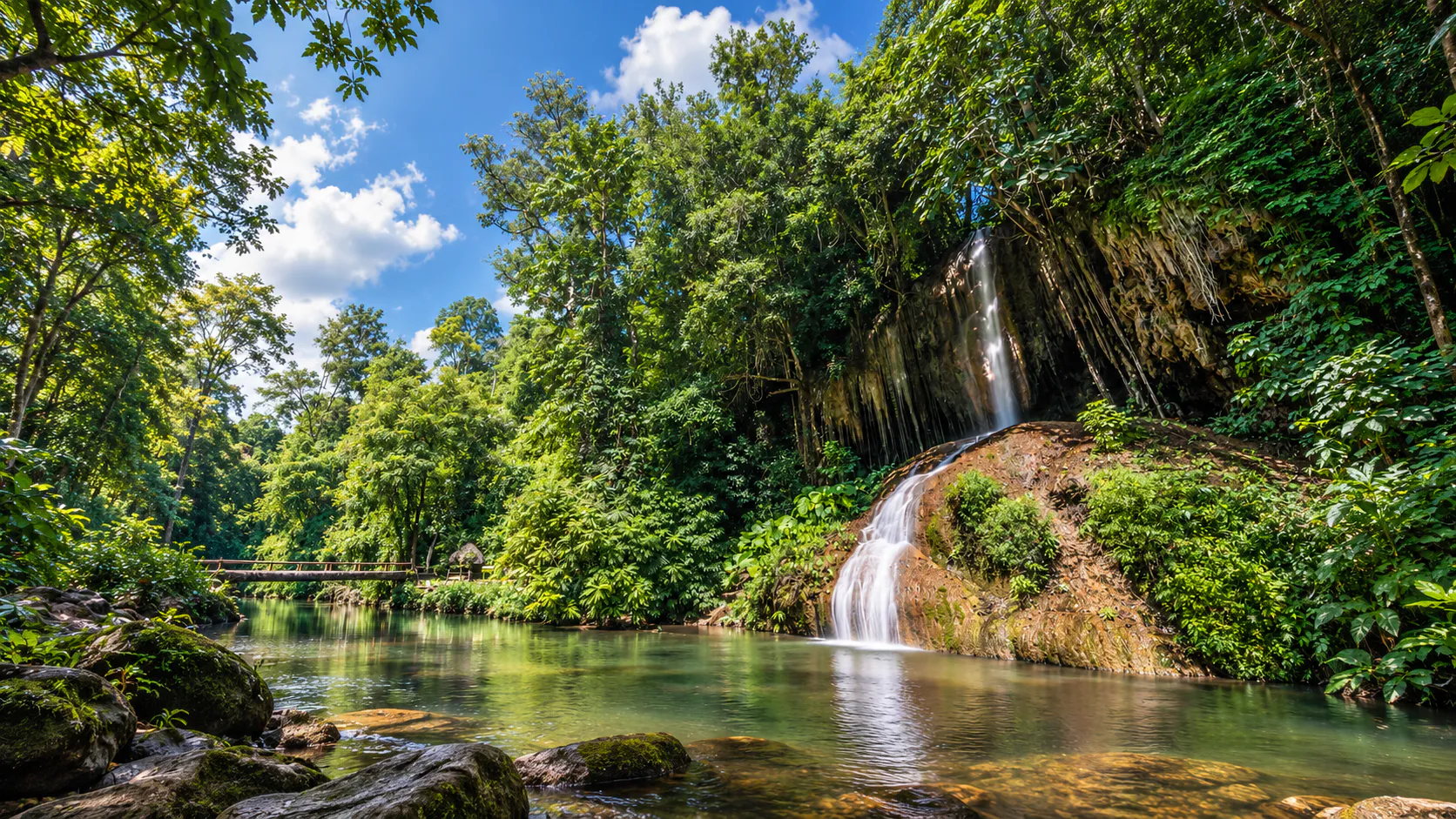
There are waterfalls in Thailand that are cold. There are waterfalls surrounded by jungle. Then there is Phu Sang, where naturally warm water flows over a limestone cliff in the middle of a mountain forest.
At the heart of Phu Sang National Park, an underground warm-water source feeds Phu Sang Waterfall. Beyond it, the protected landscape stretches through limestone cliffs, caves, streams, forest and remote viewpoints along the Thai–Lao border.
The park safeguards an important watershed across Phayao and Chiang Rai. For travellers looking beyond the north’s famous destinations, it offers something quieter and more elemental.
Warm water. Wild mountains. A quieter side of Northern Thailand.
Discover. Like. Love. Thailand.
Phu Sang at a Glance
- Location
- Phayao & Chiang Rai, Northern Thailand
- Districts
- Phu Sang and Chiang Kham, Phayao; Thoeng, Chiang Rai
- Area
- 178,049.62 rai / approximately 284.88 km²
- Elevation
- Approximately 440–1,548 m above sea level
- Highest Mountain Area
- Doi Pha Mon range
- Established
- 2 November 2000
- National Park
- Thailand’s 98th national park
- Border
- Thailand–Laos
- Signature
- Phu Sang Warm Waterfall
- Landscape
- Mountain ranges, limestone cliffs, forests, caves and streams
- Best For
- Nature, photography, families, soft adventure and road trips
The Department of National Parks lists the protected area at approximately 178,049.62 rai (284.88 km²). Its Royal Decree was published on 2 November 2000.
Why Visit Phu Sang?
Phu Sang is not primarily a summit to conquer. It is a place to see several natural systems meet:
Mountain → Forest → Limestone → Cave → Spring → Waterfall → Borderland
- A naturally warm waterfall
- Limestone mountains and cliffs
- Caves and geological formations
- Short nature walks
- Ranger-led mountain routes
- Birdwatching and forest wildlife
- Quiet road-trip scenery
- Northern borderland atmosphere
Namtok Phu Sang: The Warm Waterfall
Phu Sang Waterfall is a single-tier waterfall approximately 25 metres high. Its defining feature is the water temperature: commonly reported at around 33–35°C, warm enough to feel surprising when the mountain air is cool.
The water has no strong sulphur smell. It tumbles into a clear, greenish pool surrounded by forest and limestone, creating an intimate experience rather than a vast canyon spectacle.
ThailandLover tip: Visit on a cool morning, when warm flowing water, cool air and green forest reveal Phu Sang’s character most clearly.
How Does a Warm Waterfall Exist?
The waterfall is the final visible stage of a larger geological system. Groundwater moves through the mountain, emerges at a natural warm spring upstream, joins the stream and then crosses the limestone cliff.
Underground water → Warm spring → Stream → Limestone cliff → Warm waterfall
The warm spring environment also supports distinctive vegetation. Research in the park’s freshwater swamp forest recorded a plant community of 16 species, including plants traditionally used as medicinal resources.

A Limestone Mountain Landscape
The park rises from approximately 440 to 1,548 metres and follows the Thai–Lao border for about 30 kilometres. Mountain ridges, limestone cliffs, forested valleys, caves, streams and high viewpoints create a surprisingly varied landscape.
The farther you travel from the waterfall area, the more Phu Sang feels like genuine wilderness.
Mountain, Waterfall & Cave Highlights
Doi Pha Dam
Limestone viewpoint · approximately 1,096 m
A dramatic limestone mountain with a prominent cliff and elevated views. The walking route may require a ranger and should not be treated as a casual stroll. Confirm access with the park in advance.
Huai Pong Pha Waterfall
Forest waterfall · seasonal flow
A more conventional forest-waterfall experience for nature walks, photography and birdwatching. Flow is generally strongest after rain.
Nam Dan Cave
Limestone chambers
One of the larger cave attractions associated with the park, with underground spaces and formations shaped by limestone erosion.
Nam Lot Cave
A smaller cave experience
Compact chambers and rock formations provide another window into Phu Sang’s geology. Conditions can become slippery and dangerous after rain.
Pha Daeng Cave
Limestone, water & darkness
Natural formations and nearby water features reinforce why Phu Sang should be understood as a complete limestone landscape, not only a waterfall stop.
Forests & Wildlife
Vegetation changes with altitude, moisture and aspect. The park includes dry evergreen, mixed deciduous, dry dipterocarp, pine and montane forest. Dipterocarps, teak, Lagerstroemia, Pterocarpus, Afzelia and Xylia grow alongside bamboo, wild banana, rattan and ferns.
DNP records wildlife including serow, sambar deer, muntjac, wild boar, northern pig-tailed macaque, langur, lar gibbon, jungle cat, porcupine, civets, reptiles and numerous birds. The Asian giant or elongated tortoise is also associated with the area.
Wildlife sightings are never guaranteed. Treat Phu Sang as a forest-observation destination rather than a safari.
Birdwatching: Bring binoculars, begin early and listen around water sources, forest edges, fruiting trees and quiet trails. Calls often reveal birds before movement does.
Borderland & Watershed
Phu Sang’s mountains form part of the Thailand–Laos border landscape. From high points, views open toward border ridges and valleys. Border areas are controlled zones: remain on designated routes and never approach restricted areas without authorization.
The mountain system is also an important watershed, feeding the Lao, Ngao, Pueai, Bong and Yuan rivers. These waters support farms and communities in Phayao and Chiang Rai.
Forest → Watershed → Agriculture → Communities
When to Visit Phu Sang
- November–January · Cool Season
- The most comfortable time for walking, photography, accessible caves and mountain viewpoints. Cool mornings make the warm waterfall feel especially distinctive.
- February–April · Hot & Dry
- Lower elevations become warmer and seasonal haze may reduce mountain views. Begin outdoor activities early.
- May–October · Green Season
- Forest becomes lush and waterfalls gain flow, but rain also brings slippery trails, wet caves and changing access.
The waterfall flows year-round. Drier cool-season conditions often bring clearer water, while rainy-season conditions create greener forest and stronger flow.
A Perfect Phu Sang Day
- Early Morning
- Begin at Phu Sang Waterfall while the air is cool and the forest quiet.
- Morning
- Explore the warm spring area and nearby nature.
- Late Morning
- Continue to another accessible waterfall, trail or forest area.
- Afternoon
- If access and conditions permit, join a cave or ranger-led route.
- Late Afternoon
- Return to the lower park and enjoy the border-mountain scenery.
Doi Pha Dam and remote cave routes need significantly more time and advance arrangements.
Families, Adventure & Photography
For Families
The warm waterfall is relatively close to park headquarters and does not require a major hike, making it suitable for families, older travellers and visitors with limited hiking experience.
For Adventure Travellers
Caves, ranger-led mountain routes, limestone cliffs, forest trekking and remote viewpoints reveal a wilder Phu Sang. Deeper routes require proper planning and should follow ranger instructions.
For Photographers
- Warm Waterfall
- Include a person or forest context so the image tells the warm-water story rather than looking like a conventional waterfall.
- Cool Morning
- Look for the contrast between warm water, cool atmosphere and green forest.
- Limestone Cliffs
- Use a person near the base of the frame to communicate scale.
- Caves
- Respect lighting rules, never touch formations and allow natural darkness to remain part of the image.
Getting There & Where to Stay
The park’s main visitor area is in northern Phayao, with protected land extending into Thoeng District, Chiang Rai. The waterfall area is accessible via Highway 1093.
- From Chiang Kham
- Phu Sang is a practical day excursion.
- From Phayao City
- Allow approximately 100 km or more, depending on your route and chosen attraction.
- From Chiang Rai
- Approach via the Chiang Rai / Thoeng side; distances vary across this large mountain park.
Phu Sang District
Best for a quiet small-town stay and an early start at the waterfall.
Chiang Kham
A practical base with more accommodation, restaurants, markets and access to surrounding attractions.
Phayao City
Useful for a wider itinerary combining Kwan Phayao + Chiang Kham + Phu Sang.
What to Bring
- Comfortable walking shoes
- Water, hat and sunscreen
- Insect repellent
- Lightweight long sleeves
- Rain jacket
- Small towel and change of clothes
- Waterproof bag
- Headlamp for approved cave routes
- Camera and power bank
- Binoculars
Use proper footwear rather than sandals for cave or mountain routes.
Safety & Respect
- Waterfall
- Do not enter during unsafe conditions or when park staff advise against it.
- Caves
- Never enter an unfamiliar cave alone. Rain upstream can alter water levels quickly.
- Mountains
- Stay on designated routes and follow ranger instructions.
- Border
- Do not enter controlled or restricted areas.
- Wildlife
- Observe from a distance and never feed animals.
- Do not remove rocks or fossils
- Do not touch cave formations
- Do not write on cave walls
- Do not pick orchids or wildflowers
- Take all rubbish with you
- Respect temporary closures
Phu Sang vs Phu Chi Fa
- Choose Phu Sang
- For a warm waterfall, limestone caves, forest streams, geology and a mix of relaxed and adventurous nature.
- Choose Phu Chi Fa
- For a highland ridge, short summit walk, sunrise and sea-of-cloud photography.
They work well as complementary stops on a northern border-road trip rather than substitutes for one another.
Essential Information
- Destination
- Phu Sang National Park
- Thai
- อุทยานแห่งชาติภูซาง
- Provinces
- Phayao & Chiang Rai
- Signature Attraction
- Phu Sang Warm Waterfall
- Water Temperature
- Approximately 33–35°C
- Waterfall Height
- Approximately 25 m
- Geology
- Limestone mountains and caves
- Other Attractions
- Doi Pha Dam, Huai Pong Pha Waterfall, Nam Dan, Nam Lot and Pha Daeng caves
- Recommended Time
- 1 full day; longer for ranger-led mountain or cave routes
- Transport
- Private or rental car recommended
Before You Go
Access to caves, high viewpoints and remote routes can depend on weather, trail conditions, water levels, conservation measures, border security, ranger availability and temporary restrictions. Contact the park before travelling for Doi Pha Dam or cave routes.
- Park Office
- 146 Moo 8, Phu Sang Subdistrict, Phu Sang District, Phayao 56110
- Telephone
- +66 93 293 5099
Entrance fees, opening hours and route access can change. Confirm current information directly with the park rather than relying on older third-party listings.
Location
Find Phu Sang National Park
Phu Sang District, Phayao · Northern Thailand