



Preparatory National Park · Chiang Rai
Phu Chi Fa National Park
อุทยานแห่งชาติภูชี้ฟ้า (เตรียมการ)
Where Thailand Rises Above the Mekong
Chiang Rai · Northern Thailand · Doi Pha Mon Range
A dramatic cliff, sunrise above the mist, ancient geology and highland communities — where landscape, border culture and mountain ecology meet.
Where Thailand Rises Above the Mekong
High on the mountains of Chiang Rai, where the northern Thai landscape rises sharply toward the Lao border, Phu Chi Fa stands as one of Thailand’s most distinctive mountain viewpoints.
The name Phu Chi Fa literally evokes the image of a mountain that appears to “point toward the sky.” Its defining feature is not simply its elevation, but its dramatic geological form: a long mountain ridge ending in a steep cliff that drops toward the landscape on the eastern side.
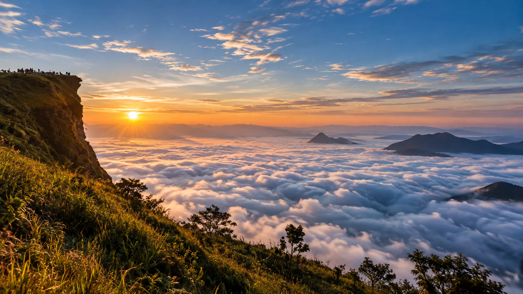
At sunrise, the silhouette of the cliff rises above layers of mist and distant mountains. Far below, the landscape extends toward Laos, while the Mekong corridor lies beyond the surrounding mountain ranges.
But Phu Chi Fa is more than a sunrise viewpoint.
It is part of the Doi Pha Mon mountain range — a landscape shaped by ancient marine sediments, tectonic forces, erosion, forests, border history, local communities and the changing relationship between people and the highlands.
For ThailandLover, Phu Chi Fa is best understood not as simply a place to “watch the sunrise,” but as a destination where geology, landscape, border culture and mountain ecology meet.
Discover. Like. Love. Thailand.
This highland cliff landscape is a standout destination in ThailandLover’s Nature & Parks collection — and pairs well with nearby Phu Sang National Park on a broader Chiang Rai–Phayao journey.
Quick Facts
- Official Thai Name
- อุทยานแห่งชาติภูชี้ฟ้า (เตรียมการ)
- English Reference
- Phu Chi Fa National Park (Proposed / Preparatory)
- Previous Status
- Phu Chi Fa Forest Park
- Province
- Chiang Rai
- Districts
- Thoeng, Khun Tan, Chiang Khong and Wiang Kaen
- Famous Viewpoint
- Phu Chi Fa summit
- Summit Elevation
- Approximately 1,628 metres above sea level
- Mountain Range
- Doi Pha Mon Range
- Border
- Thailand–Laos
- Main Landscape
- High mountain ridge, steep cliff, forest and highland valleys
- Geological Character
- Ancient sedimentary and metamorphosed rocks
- Best-Known Experience
- Sunrise above the mountain landscape and morning mist
- Established as Forest Park
- 6 February 1998
- Current Legal Status
- Area being prepared for designation as a national park
- Proposed Area
- Approximately 58,069.24 rai / 92.91 km²
The Department of National Parks states that the proposed national-park area under consideration covers approximately 58,069.24 rai, or 92.91 square kilometres. The area includes parts of several existing forest-reserve areas and is being processed under Thailand’s National Park Act framework.
Important: The famous Phu Chi Fa viewpoint is at approximately 1,628 metres according to current Department of National Parks information. Some older geological publications give different elevation figures, including approximately 1,724 metres. For current travel publishing, ThailandLover uses the current DNP figure of 1,628 metres.
Where Is Phu Chi Fa?
Phu Chi Fa is in Chiang Rai Province in northern Thailand, within the Doi Pha Mon mountain system near the Thailand–Laos border.
The landscape extends across an area associated with:
- Thoeng District
- Khun Tan District
- Chiang Khong District
- Wiang Kaen District
The famous summit is accessed from the Thai side, particularly around Ban Rom Fa Thai in Tambon Tap Tao, Thoeng District, and the surrounding highland communities.
The Department of Mineral Resources describes Phu Chi Fa as part of a long mountain system extending north–south along the Thai–Lao frontier. The steep eastern side of the range falls toward the Lao side, while the western side slopes more gradually toward the interior of northern Thailand.
Phu Chi Fa and the Thailand–Laos Border
One of the reasons Phu Chi Fa feels so dramatically different from many mountain viewpoints in Thailand is its geographic position.
The mountain range runs close to the Thailand–Laos international boundary. The eastern face of the mountain forms a dramatic escarpment, while the land beyond the cliff opens toward Laos.
From the high viewpoint, visitors can see an expansive mountainous landscape rather than a single isolated valley.
This border geography is also why visitors should treat the summit as a designated viewpoint rather than an area for unrestricted exploration.
The summit is not simply an ordinary mountain trail. It is located within a sensitive border landscape, and visitors should remain on permitted routes and follow instructions from park and security authorities.
The Meaning of Phu Chi Fa
The name Phu Chi Fa is commonly understood through the visual character of the mountain itself.
The mountain appears to rise toward the sky, with its distinctive cliff and projecting ridge creating the impression of a mountain “pointing upward.”
Local naming traditions developed around this unusual geological form. Rather than thinking of Phu Chi Fa as simply the name of a peak, it is useful to think of it as a name describing the mountain’s visual identity.
The mountain seems to point toward the sky — and that is exactly the impression visitors experience when approaching the viewpoint.
The Landscape of Doi Pha Mon
Phu Chi Fa belongs to the Doi Pha Mon mountain range, a long highland system extending through the border region of Chiang Rai and northern Thailand.
The range is characterized by:
- Steep mountain slopes
- High ridges and exposed rock faces
- Forested valleys and agricultural communities
- Cloud and mist formation
- Dramatic changes in elevation
- Long-distance mountain views
The mountain system does not end at Phu Chi Fa. Nearby landscapes include Pha Tang and other mountain viewpoints, but these should be treated as distinct destinations rather than attractions inside Phu Chi Fa itself.
The Department of Mineral Resources describes the Phu Chi Fa–Pha Tang landscape as a continuous geological and geomorphological system along the border.
Why Does Phu Chi Fa Have Such a Dramatic Cliff?
The most important story at Phu Chi Fa is written in the rocks.
The distinctive cliff is the result of the interaction between ancient marine sedimentation, tectonic deformation, uplift, tilted rock layers, differences in rock resistance, weathering, erosion and gravitational collapse.
The rocks in the Phu Chi Fa–Pha Tang area originated from sediments deposited in an ancient marine environment during the Carboniferous–Permian period, roughly 355–250 million years ago.
These sediments included limestone and other materials that later became sedimentary and metamorphic rocks. Subsequent tectonic activity uplifted and deformed the rocks.
Over geological time, erosion acted differently on rocks of different resistance. Less-resistant layers were removed more easily, while stronger limestone and marble layers resisted erosion.
This differential erosion helped create the steep and unusual cliff visible today.
The Geology of Phu Chi Fa
The geology of Phu Chi Fa is particularly interesting because the mountain preserves evidence of an ancient marine environment.
According to the Department of Mineral Resources, rocks in the wider Phu Chi Fa–Pha Tang geological area include:
- Limestone
- Marble
- Phyllite
- Schist
- Shale and related sedimentary materials
The geological sequence is associated with rocks approximately 355–250 million years old. At Phu Chi Fa, limestone and marble form more resistant portions of the mountain, while weaker layers were more easily eroded. The rock beds are also tilted — and that tilted structure strongly influences the present-day shape of the mountain.
Ancient sea → sediment → rock → tectonic uplift → deformation → weathering → erosion → today’s Phu Chi Fa cliff.
That means the famous sunrise viewpoint is also a geological record millions of years in the making.
The Phu Chi Fa Cliff
The cliff is the defining physical feature of the destination.
From the approach, the mountain appears relatively gentle. Then the landscape changes dramatically. The eastern side drops away into a steep escarpment, creating the distinctive silhouette associated with Phu Chi Fa.
The Department of Mineral Resources describes the eastern side as a steep cliff descending hundreds of metres toward the lower landscape.
The cliff is therefore not an artificial viewing platform or a single isolated rock formation. It is the exposed edge of a much larger geological structure.

Sunrise at Phu Chi Fa
Sunrise is the experience that made Phu Chi Fa famous across Thailand.
Visitors normally begin their ascent before dawn. The final approach is conducted in darkness, with the landscape gradually becoming visible as the eastern sky brightens.
The experience typically unfolds in stages:
- 1. Darkness
- The mountain is almost completely silent. The surrounding landscape is difficult to see.
- 2. First Light
- The eastern horizon begins to brighten. The outlines of distant mountains become visible.
- 3. The Mist Appears
- On suitable mornings, clouds and mist gather in the lower valleys. From above, they can resemble a white sea flowing between mountain ridges.
- 4. Sunrise
- The sun rises above the distant landscape. The cliff becomes a dark foreground silhouette while the surrounding mountains gradually gain colour.
- 5. Daylight
- As the sun rises higher, the landscape changes completely. The dramatic sunrise scene becomes a broad highland panorama.
This changing sequence is one reason Phu Chi Fa should not be treated simply as a “sunrise photo spot.” The atmosphere is part of the experience.
The Sea of Mist
The famous sea of mist at Phu Chi Fa is a weather-dependent phenomenon. It is not guaranteed every morning.
Mist develops when atmospheric conditions allow moisture and cooler air to accumulate in valleys and lower terrain. When the conditions are right, visitors standing on the high ridge can look down onto layers of cloud and mist. The effect is especially striking during cooler periods.
Clear weather does not mean a bad visit.
A cloudless morning can reveal much farther mountain views. A misty morning emphasizes atmosphere. A clear morning emphasizes geography. Both are part of Phu Chi Fa.
When Is the Best Time for Sunrise?
There is no single month that guarantees the perfect sunrise. The experience depends on cloud cover, humidity, temperature, rainfall, wind, seasonal weather patterns and local mist formation.
The cooler months are traditionally the most popular period because the combination of lower temperatures, mountain air and valley moisture can create favorable mist conditions.
Peak winter mornings can also be very cold. Visitors should prepare for temperatures substantially lower than those experienced in Chiang Rai city.
Phu Chi Fa in Winter
Winter is the season most strongly associated with Phu Chi Fa.
During the cooler season:
- Mornings can be cold
- Sunrise crowds increase
- Mist is often sought after by photographers
- Mountain visibility can be excellent
- Flowering plants may add colour to the surrounding highlands
- Accommodation in nearby communities can become busy
This is also the period when advance planning becomes important. Do not assume that arriving without accommodation will always be convenient during major holiday periods.
Highland Flowers
The wider Doi Pha Mon landscape is also associated with seasonal flowering plants.
One of the most recognizable seasonal flowers in the area is the pink Siamese wild Himalayan cherry, commonly known in Thailand as dok siang in local tourism descriptions.
The Department of Mineral Resources notes that flowering trees can create pink tones across portions of the Phu Chi Fa–Pha Tang–Doi Pha Mon landscape during the flowering season, particularly around February. The exact flowering period varies with weather.
For ThailandLover, it is better to describe this as a seasonal mountain phenomenon rather than promise visitors that the entire mountain will always be covered in pink flowers on a particular date.
Forests and Highland Ecology
Phu Chi Fa is part of a mountainous forest landscape rather than a single isolated viewpoint.
The surrounding forests provide habitat for wildlife, watershed functions, soil protection, ecological connectivity, vegetation adapted to elevation, and habitat for birds and other mountain species.
The proposed national park area is being considered partly because of the importance of its forest resources, biodiversity and landscape. The Department of National Parks describes the proposed area as having relatively rich forest conditions, ecological value and important natural landscapes.
Wildlife
Phu Chi Fa is not primarily a destination for large-animal safari experiences. Its wildlife value is better understood through the broader mountain ecosystem.
Possible wildlife encounters include forest birds, small mammals, reptiles, amphibians, insects, butterflies and other highland species.
Most visitors will not see large mammals during a short sunrise visit. This is important for responsible expectations.
Phu Chi Fa is fundamentally a mountain landscape destination, not a wildlife-viewing park.
Birdwatching
The highland environment and forest mosaic provide opportunities for birdwatching.
Birdwatchers should pay attention to forest edges, mountain slopes, agricultural–forest boundaries, flowering trees, quieter trails and early morning activity.
Sunrise is also one of the best periods for observing bird activity because many species become active shortly after dawn. However, birdwatching conditions vary significantly with season and weather.
A visitor interested in birds should allow more time than the typical sunrise-only itinerary.
The Human Landscape Around Phu Chi Fa
Phu Chi Fa does not exist in isolation from local communities.
The surrounding highlands have long been used and inhabited by communities whose livelihoods include agriculture and tourism. Villages around the mountain provide accommodation, local food, transport services, guides, agricultural products and visitor services.
The destination is not simply mountain + sunrise + tourists.
It is a living highland landscape in which conservation, local communities, agriculture and tourism interact.
A Landscape with a Complex Border History
The Phu Chi Fa region has also experienced Thailand’s modern political and security history.
Tourism Authority of Thailand materials describe the wider area as having been associated in the past with conflict involving the Communist Party of Thailand. The mountain terrain was strategically important because of its steep slopes, difficult access and proximity to the border.
As security conditions changed and road access improved, Phu Chi Fa gradually became more accessible to visitors and eventually developed into one of Chiang Rai’s most recognized mountain destinations.
This history adds another layer to the destination. The same terrain that now attracts photographers and sunrise visitors once had a very different significance.
Why Visitors Cannot Treat the Summit as an Ordinary Campsite
Because of Phu Chi Fa’s location close to the international border, visitors should follow official instructions regarding where they may walk, remain and stay overnight.
Tourism Authority of Thailand information has previously noted restrictions on overnight stays at the summit for security reasons. Rules and operating arrangements can change.
Therefore, visitors should always check current instructions with the responsible authorities before travelling, especially during high season or periods of increased border-security sensitivity.
Phu Chi Fa Forest Park → Proposed National Park
This is an important part of the destination’s modern history.
The area was officially established as Phu Chi Fa Forest Park on 6 February 1998. The current proposal seeks to elevate the protected-area framework by establishing Phu Chi Fa National Park.
In December 2025, the Department of National Parks opened a public participation process concerning the proposed national-park designation. The proposed area covers approximately 58,069.24 rai / 92.91 km² and involves parts of forest-reserve areas across the region.
The process is being undertaken under the National Park Act B.E. 2562 (2019), which requires the appropriate legal and public-participation procedures before an area can formally become a national park.
As of February 2026, the Department of National Parks was still describing the area as Phu Chi Fa National Park (Preparatory) and was instructing officials to accelerate the remaining process.
Phu Chi Fa vs. Pha Tang
These destinations are close enough to combine in a northern Thailand itinerary, but they are not the same attraction.
- Phu Chi Fa
- Known primarily for its dramatic cliff, sunrise, sea of mist, Doi Pha Mon landscape and Thailand–Laos border scenery.
- Pha Tang
- Known for dramatic mountain scenery, border landscape, rock formations, viewpoints and the distinctive Pha Bong / Siam Gate area.
The Department of Mineral Resources describes Pha Tang and Phu Chi Fa as parts of the same broader geological mountain system, but they remain distinct visitor destinations.
Phu Chi Fa vs. Phu Sang National Park
These are also different destinations.
Phu Sang National Park is another protected area in northern Thailand and can be combined with a broader Chiang Rai–Phayao journey. It should not, however, be described as part of Phu Chi Fa National Park.
The distinction is particularly important for ThailandLover’s mapping and internal-link structure.
Phu Chi Fa and the Mekong Landscape
One of the most interesting geographical aspects of Phu Chi Fa is the relationship between the mountain ridge and the Mekong region.
The mountain system runs near the Thai–Lao border, while lower landscapes toward the northeast connect visually with the wider Mekong basin.
From elevated viewpoints, visitors can understand northern Thailand not as a collection of isolated mountains but as part of a much larger cross-border landscape.
The mountains, valleys, river systems and settlements form one interconnected geographical region.
What Makes Phu Chi Fa Different?
There are many mountain viewpoints in Thailand. Phu Chi Fa has a particularly recognizable combination:
- 1. A dramatic cliff
- The cliff is the destination’s visual signature.
- 2. A high border location
- The mountain stands near the Thailand–Laos frontier.
- 3. Geological character
- Its shape reflects ancient rock layers and differential erosion.
- 4. Sunrise orientation
- The eastern-facing landscape creates a dramatic sunrise setting.
- 5. Valley mist
- When weather conditions cooperate, clouds and mist fill the lower valleys.
- 6. Highland communities
- Local villages form an important part of the visitor experience.
- 7. Seasonal landscapes
- Winter weather and seasonal flowering create a changing visual character.
The Phu Chi Fa Experience
A good Phu Chi Fa visit is not simply: arrive → walk → photograph sunrise → leave.
A better experience is: arrive in the highlands → understand the mountain → experience the village landscape → wake before dawn → walk toward the viewpoint → watch the landscape emerge → stay after sunrise → explore the surrounding highlands.
The post-sunrise period is particularly important. Once the crowds begin leaving, the mountain becomes quieter. The landscape that looked almost monochromatic before sunrise gradually reveals green forests, agricultural fields, distant mountains, rock structures, village landscapes and changing cloud patterns.
A Recommended One-Day Experience
- Before Dawn
- Stay in a nearby village rather than attempting to arrive immediately before sunrise. Prepare warm clothing, a headlamp or flashlight, drinking water, comfortable shoes, a camera and a small backpack.
- Early Morning
- Leave accommodation according to current local transport and access arrangements. Follow designated routes. Do not attempt to walk beyond permitted areas.
- Sunrise
- Reach the viewpoint before the first light. Do not focus only on the sun — watch the entire horizon. The changing colours and layers of mountains are often more visually interesting than the sun itself.
- After Sunrise
- Remain for another 20–40 minutes if conditions allow. The landscape changes rapidly after sunrise. Mist may move through the valleys while the mountains become progressively clearer.
- Morning
- Return toward the village. Have breakfast locally — an opportunity to experience the highland community rather than treating the area as a roadside tourist stop.
- Late Morning
- Explore nearby highland scenery or continue toward another destination such as Pha Tang, depending on the route and current road conditions.
A Two-Day Phu Chi Fa Itinerary
Day 1 — Arrive in the Highlands
- Afternoon: Arrive in the Phu Chi Fa area, check into local accommodation, explore the surrounding village and mountain landscape.
- Late afternoon: Find a viewpoint away from the main summit if permitted. Watch the mountains change colour toward sunset.
- Evening: Have a local dinner. Prepare warm clothing and equipment for the following morning. Sleep early.
Day 2 — Sunrise at Phu Chi Fa
- Before dawn: Wake early. Follow current transportation and access instructions.
- Sunrise: Experience the viewpoint.
- Morning: Walk back toward the village. Have breakfast.
- Late morning–afternoon: Continue to another destination in the Doi Pha Mon / Chiang Rai border region.
Photography Guide
Phu Chi Fa is particularly rewarding for landscape photographers.
Best subjects
- The cliff silhouette
- Use the distinctive cliff as the foreground.
- Layers of mountains
- Mist can create multiple layers of tonal depth.
- Sunrise
- Use a wide composition to capture the entire eastern horizon.
- Human scale
- A person standing safely at an approved viewpoint can communicate the enormous scale of the landscape.
- Village landscapes
- Photographing the surrounding communities can add cultural context to the destination.
Photographing the sea of mist
Do not rely exclusively on a telephoto lens.
A wide-angle lens is useful when the mist fills the valley, the cliff forms a strong foreground, or multiple mountain layers are visible.
A telephoto lens becomes more useful when distant ridges are separated by mist, cloud layers create compressed mountain layers, or the sunrise creates strong atmospheric depth.
When the mist does not appear
No mist does not mean a failed trip.
A clear morning may provide longer visibility, sharper mountain silhouettes, better geological appreciation, stronger landscape definition and views deeper into the surrounding region.
ThailandLover presents both experiences rather than promising a “sea of mist” every morning.
What to Wear
For winter sunrise visits, bring:
- Warm jacket
- Long trousers
- Closed shoes and socks
- Light gloves if sensitive to cold
- Hat or beanie if necessary
The temperature can feel significantly colder before sunrise than during the daytime. In other seasons, weather can change quickly in the mountains. A light rain jacket is useful during wetter periods.
Safety at Phu Chi Fa
The cliff is beautiful precisely because it is steep. That also makes it dangerous.
Visitors should:
- Stay on designated paths
- Respect barriers and warning signs
- Never climb over protective boundaries
- Avoid standing too close to the cliff edge
- Be particularly careful in darkness
- Use a flashlight when walking before dawn
- Avoid running on uneven terrain
- Follow staff instructions
- Remain within permitted visitor areas
- Never attempt to cross the international border
Wet rocks and low visibility can significantly increase risk.
Sunrise safety
Most accidents at sunrise viewpoints happen because visitors arrive before daylight.
Bring a proper light.
Do not rely solely on a mobile phone flashlight. A headlamp leaves both hands free and makes walking considerably easier. Wear shoes with good grip.
Weather and Visibility
Mountain weather can change quickly. Possible conditions include heavy mist, strong wind, rain, low cloud, cold temperatures and reduced visibility.
Visitors should check current weather and official access conditions before travelling.
Do not assume that conditions seen in photographs on social media represent conditions on your travel date.
High Season and Visitor Management
Phu Chi Fa has become extremely popular, especially during the cool season and major holidays.
In December 2025, the Department of National Parks announced measures to manage private vehicles during the high season, including shuttle arrangements from multiple points. This demonstrates that access management can change according to visitor volume.
Do not publish fixed shuttle times, parking rules or vehicle-access arrangements as permanent information.
For ThailandLover, these should be presented as: “Check the latest local access and shuttle arrangements before your visit.”
Getting to Phu Chi Fa
Phu Chi Fa is a mountain destination, so private transport or organized transport is generally more practical than relying on conventional public transport alone. Several approach routes exist.
- From Chiang Rai
- One documented route follows Chiang Rai → Thoeng → Route 1155 → Phu Chi Fa. The Department of Mineral Resources gives an approximate distance of 111 km from Chiang Rai city via this general route.
- From Phayao / Chiang Kham
- Another approach comes through Phayao → Chiang Kham → Route 1093 → Phu Chi Fa. Useful for travelers combining Phu Chi Fa with destinations in Phayao and the eastern Chiang Rai highlands.
- From the Chiang Khong / Wiang Kaen Side
- Travelers coming from the Mekong-side route can approach through the northern part of the Doi Pha Mon landscape — particularly interesting for a multi-stop border-region itinerary.
Roads to Phu Chi Fa
The final roads are mountainous. Expect curves, elevation changes, narrow sections, slower travel than map distance may suggest, and occasional weather-related difficulties.
Drive conservatively. Do not calculate arrival time simply by dividing distance by highway speed.
Where to Stay
Accommodation is concentrated around surrounding communities rather than at the summit itself.
Typical options include local guesthouses, homestays, small resorts, mountain lodges and community accommodation.
Staying locally has two advantages:
- You can reach the sunrise viewpoint early.
- Your spending contributes more directly to the local tourism economy.
During peak winter weekends and public holidays, advance booking is strongly advisable.
Food Around Phu Chi Fa
The food experience is more local and community-oriented than resort-oriented.
Depending on where you stay, visitors may encounter northern Thai dishes, rice-based meals, soups, grilled foods, vegetables, local agricultural produce and simple breakfast meals before sunrise.
The best approach is not to expect a large tourist restaurant scene. Phu Chi Fa works better as a destination for experiencing highland community life.
Responsible Tourism
Phu Chi Fa’s greatest asset is its landscape. That landscape is also fragile.
- Stay on designated trails
- Do not create unofficial shortcuts.
- Do not litter
- Carry all waste back with you.
- Do not pick flowers
- Seasonal mountain flowers are part of the ecosystem.
- Do not disturb wildlife
- Do not feed animals or attempt to attract birds.
- Respect local communities
- Ask before photographing people, homes or private agricultural areas.
- Respect the border
- Never cross restricted areas or approach military/security installations.
- Keep noise low
- Especially before sunrise.
Phu Chi Fa for Families
Families can enjoy Phu Chi Fa, but the cliff environment requires active supervision. It is especially suitable for families with older children who can walk safely on uneven terrain.
For young children: hold hands where necessary, use proper footwear, avoid cliff edges, carry a light source, and do not allow children to run near viewpoints.
The destination is educational as well as scenic. Children can learn about geology, mountain ecosystems, weather, borders, local communities and responsible tourism.
Phu Chi Fa for Couples
The destination’s sunrise atmosphere makes it popular with couples. But ThailandLover would describe the appeal differently from a generic “romantic destination.”
The real attraction is the shared experience of darkness → first light → mist → sunrise → mountains. That transition gives the destination its emotional character.
Phu Chi Fa for Photographers
Highly suitable. Best subjects include sunrise, mist, mountain layers, cliff silhouettes, seasonal flowers, villages, agricultural landscapes and geological formations.
Bring a wide-angle lens, medium telephoto, tripod if permitted and practical, headlamp, spare batteries and weather protection.
Phu Chi Fa for Geology Lovers
Phu Chi Fa deserves more attention from geology enthusiasts. The destination demonstrates how landscape can be controlled by geological structure.
Visitors can observe tilted strata, resistant limestone/marble, weaker sedimentary layers, differential erosion, steep escarpments and gravitational rock collapse.
The mountain is effectively an open-air lesson in geomorphology.
The geological story in one sequence
- Ancient marine environment
- Sediments accumulated in a Carboniferous–Permian sea.
- Sediments became rock
- Limestone, marble and related materials formed.
- Tectonic uplift
- Forces uplifted and deformed the rocks; layers became tilted.
- Weathering and erosion
- Weaker material was removed; more resistant limestone/marble remained.
- Today’s cliff
- Gravity and erosion shaped Phu Chi Fa’s distinctive landscape.
This geological story is documented by the Department of Mineral Resources.
Phu Chi Fa as a ThailandLover Experience
At ThailandLover, the destination can be interpreted through four layers:
- SEE
- The cliff. The mountains. The mist. The sunrise. The distant Lao landscape.
- UNDERSTAND
- The geology. The border. The forest. The history.
- FEEL
- The cold before dawn. The silence. The first light. The sudden scale of the landscape.
- RESPECT
- The mountain. The forest. The local communities. The border environment.
Phu Chi Fa is not just a viewpoint. It is a landscape with a story.
The Best Way to Experience Phu Chi Fa
Do not rush. Do not arrive five minutes before sunrise and leave immediately afterward.
Stay overnight. Wake before dawn. Walk quietly. Watch the landscape emerge. Stay after sunrise. Eat locally. Explore the surrounding highlands. Learn why the mountain looks the way it does.
That is the difference between visiting Phu Chi Fa and actually experiencing it.
Things You Should Not Assume About Phu Chi Fa
- “There will always be a sea of mist.”
- No. Mist depends on weather and atmospheric conditions.
- “The summit is a normal campsite.”
- No. The summit is within a sensitive border landscape and overnight arrangements/restrictions must be checked.
- “Phu Chi Fa is already officially a national park.”
- Not yet as of September 2026. The area remains under the national-park preparation process.
- “Pha Tang is part of Phu Chi Fa.”
- No. They are separate visitor destinations within the broader Doi Pha Mon mountain landscape.
- “The elevation is universally reported as 1,724 metres.”
- Different official/technical sources give different figures. The current DNP information gives approximately 1,628 metres, which ThailandLover uses for current travel information.
- “The sunrise is guaranteed to be visible.”
- No. Cloud and weather can completely change the experience.
ThailandLover Travel Summary
- Destination
- Phu Chi Fa
- Province
- Chiang Rai
- Region
- Northern Thailand
- Mountain Range
- Doi Pha Mon
- Elevation
- Approximately 1,628 m
- Landscape
- Mountain ridge and dramatic cliff
- Border
- Thailand–Laos
- Signature Experience
- Sunrise and mountain mist
- Geological Age
- Major rock sequence approximately 355–250 million years
- Previous Status
- Phu Chi Fa Forest Park
- Forest Park Established
- 6 February 1998
- Current Status
- Proposed / Preparatory National Park
- Best Known For
- Sunrise, sea of mist, cliff landscape and highland scenery
- Recommended Stay
- 1–2 days
- Travel Style
- Nature · Landscape · Photography · Geology · Culture · Slow Travel
Frequently Asked Questions
- Is Phu Chi Fa a national park?
- As of September 2026, the area is still being prepared for designation as a national park. It was established as Phu Chi Fa Forest Park in 1998, and the Department of National Parks is progressing the process toward national-park designation.
- How high is Phu Chi Fa?
- The current Department of National Parks information identifies the summit viewpoint at approximately 1,628 metres above sea level.
- Where is Phu Chi Fa?
- Phu Chi Fa is in Chiang Rai Province in northern Thailand, within the Doi Pha Mon mountain range near the Thailand–Laos border.
- Is Phu Chi Fa in Chiang Rai?
- Yes. The famous Phu Chi Fa viewpoint is in Chiang Rai Province.
- Can you see Laos from Phu Chi Fa?
- Yes. The mountain stands immediately adjacent to the Thailand–Laos border landscape, and the eastern panorama extends toward Laos.
- Can you see the Mekong River?
- The wider landscape is connected to the Mekong basin, and the Department of Mineral Resources describes the mountain system in relation to the Mekong-side border landscape. Visibility of the river itself depends on viewpoint, weather and atmospheric conditions.
- Is there always a sea of mist?
- No. The sea of mist is weather-dependent.
- What is the best season to visit?
- The cool season is traditionally the most popular period, particularly for sunrise, cold-weather atmosphere and potential morning mist. However, every season offers a different landscape.
- Is Phu Chi Fa suitable for children?
- Yes, with appropriate supervision. The steep cliff environment means parents must pay particular attention to children around viewpoints.
- Can I camp at the summit?
- Do not assume that camping or overnight stays at the summit are permitted. Because the area is near the international border, visitors should follow current official restrictions and instructions.
- Is Phu Chi Fa difficult to reach?
- The destination is accessible by road, but the surrounding mountain roads contain curves and elevation changes. The final approach should be driven carefully.
- Can I visit Phu Chi Fa and Pha Tang together?
- Yes. They are geographically close and belong to the broader Doi Pha Mon mountain landscape, although they are separate destinations.
- What should I bring?
- For a sunrise visit: warm clothing, comfortable shoes, headlamp, drinking water, rain protection, camera, power bank and a small backpack.
Related Destinations
- Phu Sang National Park
- A separate protected area in northern Thailand — combine on a Chiang Rai–Phayao journey, but keep it distinct from Phu Chi Fa.
- Nature & Parks
- More protected landscapes across ThailandLover’s national-park collection.
Location
Find Phu Chi Fa
Tap Tao, Thoeng, Chiang Rai · Doi Pha Mon Range