


Watershed Park · Chiang Mai & Lamphun
Mae Takhrai National Park
อุทยานแห่งชาติแม่ตะไคร้
The Forests That Feed Chiang Mai’s Rivers
Doi Saket · Mae On · San Kamphaeng · Lamphun
A mountain watershed of forests, reservoirs, waterfalls and quiet northern landscapes. Not a famous summit. A place where water begins.
A Park Born from the Watershed
Not every national park in Thailand needs a famous summit. Some matter because of what happens below the mountains. Mae Takhrai is one of them.
Its forests rise across the ridges east of Chiang Mai and extend into Lamphun. They form a watershed for streams that eventually join the Ping River system — Mae Takhrai, Mae On, Mae Tha and Mae Kuang among them. Inside the boundary there are mountain forests, reservoirs, waterfalls, cliffs, high ridges, bamboo, pine and montane forest, and communities whose lives have long been tied to these streams.
The forest captures the water. The streams carry it. The reservoirs store it. The rivers take it toward the lowlands.
This is a landscape you go to understand, not only to photograph. Come close enough to Chiang Mai for a weekend. Stay long enough to see how a northern forest quietly supports life far beyond the park.
At a Glance
- 131st
- National park of Thailand. Established 13 December 2017.
- 221,446 rai
- About 354.3136 km² — the area in the 2017 Royal Decree.
- 400–2,030 m
- An approximate elevation range, from foothills to high ridges.
- Plan by zone
- The reservoir is not the route to every waterfall or ridge.
- Thai name
- อุทยานแห่งชาติแม่ตะไคร้
- Provinces
- Chiang Mai and Lamphun
- Main areas
- Doi Saket, San Kamphaeng, Mae On and surrounding forest in Chiang Mai; Ban Thi and Mueang Lamphun in Lamphun
- Headquarters
- Pa Miang Subdistrict, Doi Saket, Chiang Mai
- Landscape
- Mountain ranges, watersheds, forests, reservoirs, waterfalls and cliffs
- Forests
- Mixed deciduous, dry dipterocarp, dry evergreen, hill evergreen, tropical evergreen and lower montane coniferous
- Water systems
- Mae Takhrai, Mae On, Mae Tha and Mae Kuang
- Main visitor zone
- Mae Takhrai Reservoir, Tha Nuea, Mae On
- Nature trail
- About 3 km around the reservoir
- Character
- Quiet, watershed-focused, close to Chiang Mai
Where the City Ends
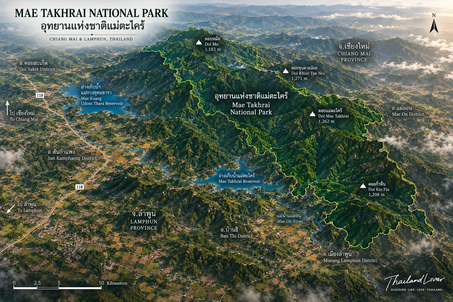
Mae Takhrai occupies a large mountainous country across Chiang Mai and Lamphun. The Chiang Mai side is associated with Doi Saket, San Kamphaeng, Mae On and the forests between them. The Lamphun side is associated with Ban Thi and Mueang Lamphun. It is geographically close to the city. Environmentally, it is not an extension of the city.
East and southeast of Chiang Mai, the ground changes in a sequence worth noticing: foothills, then forest, then ridges, then watersheds. That transition is the beginning of Mae Takhrai. The forest is not scenery. It is infrastructure. Natural infrastructure.
From Foothills to Doi Langka
The landscape rises from about 400 metres to around 2,030 metres. Temperature, moisture, vegetation and wildlife habitat change with that climb. That is why one relatively compact park can hold very different forests.
Doi Langka is the higher side — the mountain system east of Chiang Mai, not the reservoir shoreline. Lower elevations bring mixed deciduous forest, dry dipterocarp and bamboo. Higher ground moves toward hill evergreen and montane vegetation. That vertical sequence is one of the strongest ecological stories in the park.
Easy nature escape
Mae Takhrai Reservoir, the short nature trail, and a night beside the water. This is the park most visitors should begin with.
Serious mountain trekking
Doi Langka and the high ridges: steep climbs, remote forest, changeable weather, limited facilities, overnight camping, and local guiding where it is required. Do not confuse the two.
Six Forests, One Mountain
The forest is not one ecosystem. It is a vertical sequence.
- 01 · Mixed deciduous
- Highly seasonal. Many trees shed in the dry months and return to green with the rains.
- 02 · Dry dipterocarp
- A northern character forest. Open, golden and dry when the rains have gone.
- 03 · Dry evergreen
- More moisture than typical dry dipterocarp, so the green lasts longer.
- 04 · Hill evergreen
- Higher, cooler slopes, with vegetation adapted to mountain conditions.
- 05 · Tropical evergreen
- Humid pockets of denser evergreen forest.
- 06 · Lower montane coniferous
- Coniferous elements at higher elevations, part of the mountain’s ecological range.
A walk upward can move from open dry forest into mixed deciduous, then denser evergreen, then montane vegetation. Photographers should not assume the dry season is the ugly season. In northern Thailand the dry forest has its own beauty: brown, gold, amber, and deep green in different patches.
Mae Takhrai Reservoir
Tha Nuea, Mae On · the accessible landscape
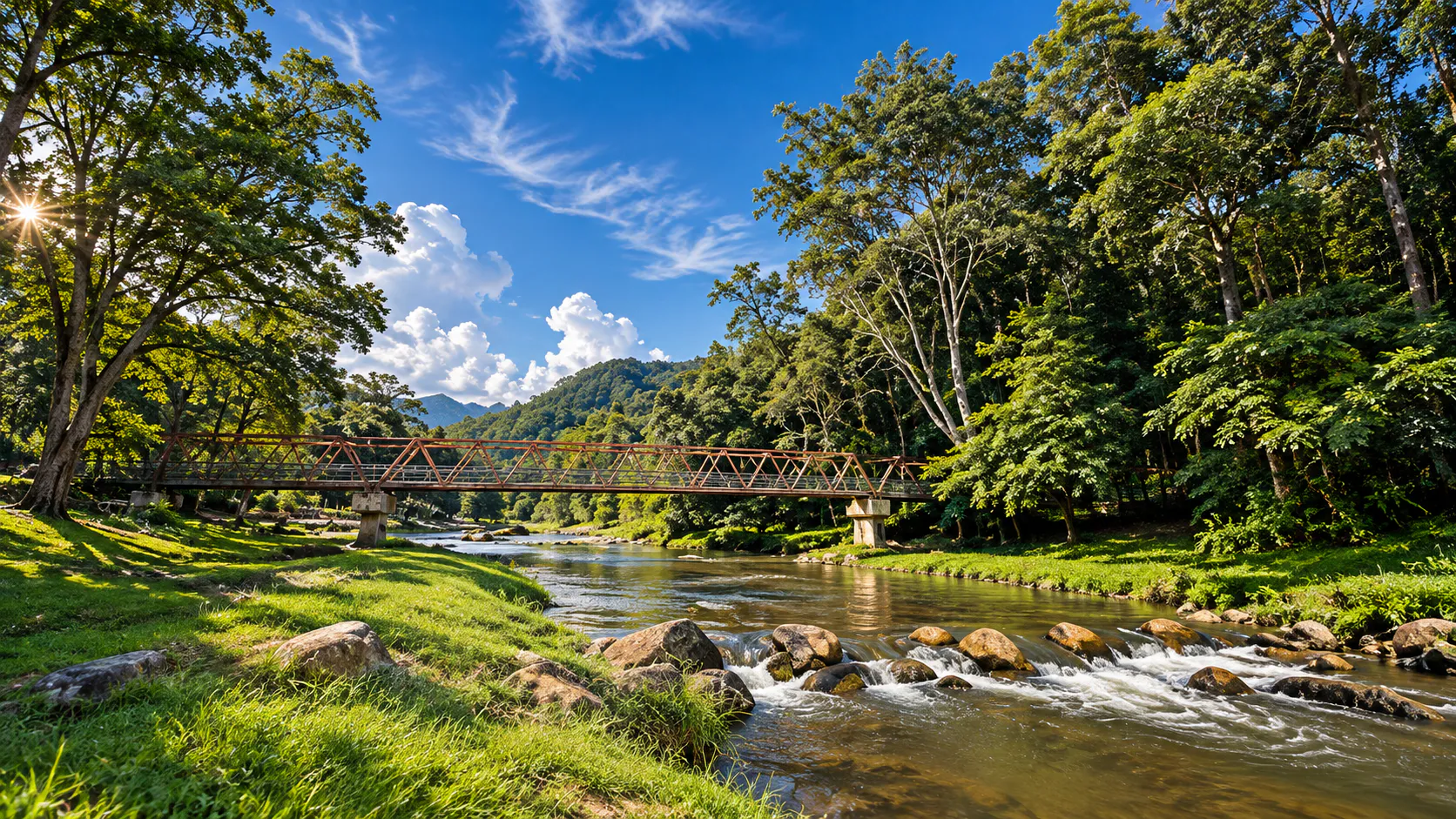
For most visitors, the reservoir is the right place to begin. It sits in mixed deciduous forest and bamboo, with hills, water and short trails. It is much more accessible than the remote ridges. The water is not only storage. It opens a slower landscape inside the forest: reflected hills, a shoreline, shade.
A nature-study route of about 3 kilometres runs around the reservoir. Government tourism information identifies it specifically. It is forest, water, bamboo, seasonal vegetation, birds and small wildlife — nature without committing to a full-day mountain trek. Particularly good for families and first visits.
Camping here has historically been one of the park’s stronger experiences: water, forest and mountain in one place, closer to simple outdoor living than to luxury camping. Cool-season nights are the point. Confirm current campsite availability, seasonal closure, fire restrictions and water before you travel.
Waterfalls, and How Far They Ask You to Walk
- Tad Moei Waterfall
- Historical park information describes a fall of about 15 metres, deeper in the park than the reservoir. After a checkpoint, visitors have had to walk about 3 kilometres through dry evergreen forest — ironwood, yang, yang daeng and other native trees. The walk is part of the attraction. You are no longer at a roadside view. You are inside the watershed. Confirm current access. Wet rocks are not a climbing wall.
- Mae Takhrai Waterfall
- A smaller, single-drop fall associated with the Mae Takhrai tourism zone near the reservoir. Historical access describes about 6 kilometres of walking along streams and forest slopes. Surveys along the route have recorded wild mushrooms, wild mango, wild rambutan-related forest species and seasonal flowers. The trail is the ecological journey. The waterfall is the reason to start it.
- Mae Tong Waterfall
- A lesser-known series of about five cascades, historically described with drops from roughly 4 to 25 metres. Named sections include Nang Khoi, Kaeng Sai, Pha Taek, Op Pha Luang and Sai Rung, the highest at about 25 metres. Access toward the Mae Tong community intersects with ground outside the national-park boundary. Treat it as a waterfall of the wider landscape, and confirm the route locally. Do not imply that every step lies inside the gazette.
In the rains, flow increases, the forest tightens, and streams get louder. In the dry season, flow can shrink and the woodland opens. Photographs from different months can look like different places. That is seasonal truth, not a trick of the camera.
Stars on Earth
Historical tourism information describes viewpoints along the Mae Takhrai–Huai Kaew mountain road. On a clear day the higher points can open toward Mae On, Doi Saket, Lamphun, Chiang Mai and the ranges around them. At night, distant lights have led visitors to call one viewpoint Dao Bon Din — Stars on Earth, because the valley can look like a second constellation.
By day the mountains dominate. After dark the cities appear below, and the forest goes quiet. It is worth presenting. It should not be written as an officially branded attraction unless current park signage confirms the name. Treat it as a local and visitor nickname.
The Huai Kaew road is better understood as a mountain road through a watershed forest than as a means of arrival. That is what makes it attractive to independent road-trippers. Other water bodies in the wider country — Huai Pha Na, Huai Khamin, Huai Bong, Huai Mae Takhrai, Mae Kuang Dam, Mae On Dam — should not all be treated as developed attractions inside the park. Some are water-management features of the broader watershed. A geographical feature is not automatically a tourist stop. Mae Kuang helps explain the forest. It is not the core park experience.
Forest, Tea, and the People Beside Them
Mae Takhrai has never been simply forest versus people. A royal visit to Ban Mae Takhrai in 1982 looked at living conditions and livelihoods. The development that followed worked on occupation, quality of life, community, and conservation together. The wider mountain country includes Royal Project centres, including the Teen Tok Royal Project Development Centre within the park landscape, working with communities on livelihood and natural-resource conservation.
The mountains east of Chiang Mai have a long association with miang — fermented tea leaves of the north. Traditional cultivation often depends on tree cover. Forest shade, tea, livelihood and mountain culture are one chain, not four attractions. That is different from open-field agriculture.
Life in a Layered Forest
A wide elevation range and several forest types mean habitat, not a wildlife show. Government records have included barking deer, deer, gibbons and wild boar, along with reptiles, amphibians, butterflies and forest insects. Older park notes mention junglefowl, magpies, drongos, woodpeckers, mynas, owls, coucals and herons. Composition changes with habitat and season. Sightings are never guaranteed.
Birdwatchers should treat the reservoir, bamboo, mixed deciduous forest and the higher evergreen separately. Different bird communities occupy different floors of the mountain. After rain, lizards, snakes, tortoises, monitor lizards, frogs and tree frogs become easier to notice. Historical notes also record swallowtails and forest beetles. The rainy season is the better season for insects and for a quiet walk that reveals a different forest.
When to Go
- November – February
- Best overall. Cooler air, comfortable walking, clearer ridges when the weather agrees, good camping, sunrise and night-sky photography.
- March – May
- Dry and hot. Golden, open dipterocarp. Also the burning season: smoke, haze, poor visibility, high PM2.5. Check the air before you drive up for a view.
- June – October
- The forest comes alive. Reservoirs rise. Waterfalls strengthen. Moss and fungi appear. Trails get slippery, and some remote places may close. The most dramatic season, and the hardest underfoot.
| Experience | Best period |
|---|---|
| Camping | November–February |
| Viewpoints and night lights | Cool, clear nights — weather dependent |
| Waterfalls | Rainy season, and after rainfall, if access is safe |
| Forest photography | Green in the rains; gold in the dry forest |
| Butterflies and insects | Rainy season |
| Long trekking | Cooler months, generally |
Go by Zone, Not by One Pin
More than 350 km². Several watersheds. Several mountain roads. The headquarters is not the start of every walk.
- From Chiang Mai
- A common approach is the Doi Saket / Mae On side. Day trip, weekend camp, or a slower road trip. Overnight is better if you want the forest after dark.
- From Doi Saket
- Toward Pa Miang and the headquarters. Useful if you are combining the park with highland communities and Royal Project country.
- From Mae On
- The reservoir, Tad Moei and Mae Takhrai Waterfall are most closely associated with this side.
- From Lamphun
- The forest continues toward Ban Thi and Mueang Lamphun. Confirm the attraction. There is not one entrance for the whole park.
- Zone 1 · Reservoir
- Easy nature, camping, short walking, families, a first visit.
- Zone 2 · Tad Moei
- A real walk into forest and a waterfall.
- Zone 3 · Mae Takhrai Waterfall
- Stream and slope. Seasonal. Not a roadside stop.
- Zone 4 · Viewpoints
- Landscape, long views, sunset and night photography, when the air is clear.
- Zone 5 · Doi Langka
- Serious trekking. Multi-day. Experienced travellers, and a guide when the route requires one.
Who It Is For
Come if you want
- A nearby escape from Chiang Mai
- Reservoir camping and a short nature trail
- Waterfall walks that ask something of you
- Birds across several forest types
- Mountains, water, forest and city lights in one composition
- A slower weekend, not a checklist
Look elsewhere if you want
- A luxury resort inside the park
- A single iconic landmark
- Every waterfall beside the car
- Guaranteed wildlife
- Highly developed viewpoints
The reservoir and the short trail work for families and beginners. Remote falls and high ridges do not. The park is landscape and ecology more than spectacle.
Before You Walk
- Day trip
- Water, sun protection, comfortable shoes, insect repellent, a power bank
- Camping
- Tent, sleeping bag, headlamp, warm layers, rain cover, food, drinking water, a first-aid kit
- Hiking
- Hiking shoes, an offline map, poles if you use them, extra water, and someone who knows your route
- Wet rock at a waterfall is not a path. Do not climb the face.
- Streams rise quickly after rain. Do not cross them in a downpour.
- Mountain roads are narrow, steep and slippery. Drive slowly. Do not assume a night return is simple.
- In fire season, check PM2.5 before you go up for a view.
- Do not assume mobile coverage on remote trails. Use a local guide when the route requires one.
A Watershed Asks More of a Visitor
What you do here does not stay at the attraction. The water leaves the mountain.
- Do not pollute streams or reservoirs.
- Do not collect plants, mushrooms or rocks.
- Never feed or chase animals.
- Keep the forest quiet. Sound travels.
- Respect villages, homes, farms and cultural sites, including miang gardens.
- Stay on permitted trails. The best visit leaves the landscape unchanged.
The Boundary Is Still a Conversation
In 2025, the Department of National Parks began a formal public-participation process on a partial withdrawal of areas from Mae Takhrai. The areas under consideration included about 3,650.77 rai in the Ban Huai Bong community forest, Tha Nuea, Mae On, and about 682.65 rai in On Tai, San Kamphaeng. The process is tied to community-forest status and overlapping land management.
This does not mean the park is being dismantled. It concerns specific places. Until a new legal instrument changes the boundary, the established area remains the approximately 221,446 rai of the 2017 Royal Decree.
Protected areas are not static lines. People live around them. Community forests exist. Agriculture exists. Water crosses administrative boundaries. The forests here support communities that have depended on mountain resources for generations. The work is to keep the forest without ignoring people, and to protect water without destroying livelihoods. That is part of the national-park story. Not a footnote.
ThailandLover Signature Experiences
- 01 · Walk the reservoir
- About 3 km. The gentle introduction.
- 02 · Camp beside the water
- Stay after the day visitors leave.
- 03 · Hike to Tad Moei
- Deeper forest, and a fall of about 15 metres if the route is open.
- 04 · Follow the Mae Takhrai forest route
- Stream and mountain, not a roadside photograph.
- 05 · Watch the ridges
- See the scale of the watershed from the mountain road.
- 06 · Look for the stars on earth
- On a clear night, city lights can scatter across the valley. A nickname, not a branded stop.
- 07 · Climb into a different forest
- The vegetation changes as you go up. That is the point.
- 08 · Read the water
- Reservoir, then mountain, then forest. The relationship is the attraction.
ThailandLover Quick Verdict
- Natural beauty
- Quiet, layered, and stronger the longer you stay.
- Forest diversity
- Six communities, from dry dipterocarp to montane forest.
- Reservoir landscape
- The best first hour in the park.
- Waterfalls
- Worth the walk. Not roadside theatre.
- Mountain views
- Clear-season roads, and lights in the valley after dark.
- Birdwatching
- Several habitats. Several bird communities.
- Wildlife
- Habitat. Not a guarantee.
- Hiking
- From a 3 km loop to Doi Langka. Choose deliberately.
- Camping
- One of the strongest reasons to stay.
- Photography
- Water, forest, mountain, and the city below.
- Accessibility
- Close to Chiang Mai. Not one compact park.
- Family friendliness
- At the reservoir. Not on the remote falls.
- Facilities
- Enough for a simple night. Not a resort.
- Adventure
- If you leave the shoreline.
- Slow travel
- The pace that suits it.
- Mass tourism
- Low. Keep it that way.
Best for: campers, nature lovers, photographers, hikers, birdwatchers, Chiang Mai weekend travellers and slow travellers.
Less suitable for: visitors looking for luxury facilities or a single spectacular landmark.
Frequently Asked Questions
- Is Mae Takhrai officially a national park, and when was it established?
- Yes. It is Thailand’s 131st national park. The Royal Decree took effect on 13 December 2017.
- Where is it, and how large is it?
- It spans parts of Chiang Mai and Lamphun — Doi Saket, San Kamphaeng, Mae On, and areas associated with Ban Thi and Mueang Lamphun. The 2017 decree sets the area at about 221,446 rai / 354.3136 km². Do not use the older 320,750 rai figure as the current gazette.
- Is the reservoir inside the park? How long is the trail?
- Yes. Mae Takhrai Reservoir is a principal visitor area, in mixed deciduous forest and bamboo. The nature-study route around it is about 3 kilometres.
- Is Tad Moei the same as Mae Takhrai Waterfall?
- No. Tad Moei is historically described as about 15 metres high, reached by a vehicle journey and then about 3 kilometres of forest walking. Mae Takhrai Waterfall is a different fall, associated with the reservoir zone, with a historical walk of about 6 kilometres. Confirm both before you go.
- Can I camp, and is it suitable for families or a day trip?
- Camping has historically been available around the reservoir. Check current operation. The reservoir and short trail suit families and beginners. Remote falls and high ridges do not. A day trip from Chiang Mai is practical. A night is better.
- Can I see Chiang Mai? What is “Stars on Earth”?
- From some higher viewpoints, historical accounts report broad views toward Chiang Mai, Lamphun, Doi Saket and Mae On. Visibility depends on weather and haze. “Stars on Earth” is a nickname for night lights in the valley, not automatically an official attraction name.
- Is it connected to Mae Kampong? Does it have wildlife? Is there wildfire risk?
- The wider mountains are close to Mae Kampong. The village is a separate community-tourism destination and is not part of the national park. The forest holds barking deer, deer, gibbons, wild boar, birds, reptiles, amphibians and insects. Sightings are not guaranteed. Like much of the northern forest, the park is exposed to seasonal fire and smoke. Check conditions in the dry months.
More of the Mountains East of Chiang Mai
- Si Lanna National Park
- Another Chiang Mai water landscape, if the journey stays with reservoirs and forest.
- Chae Son National Park
- Hot springs and forest further into the northern ranges.
- Khun Chae National Park
- Higher country nearby, where the forest continues past one park boundary.
- Doi Suthep–Pui National Park
- The mountain immediately above the city — a different kind of Chiang Mai nature.
Location
Find Mae Takhrai
Pa Miang, Doi Saket, Chiang Mai · the reservoir is in Tha Nuea, Mae On