

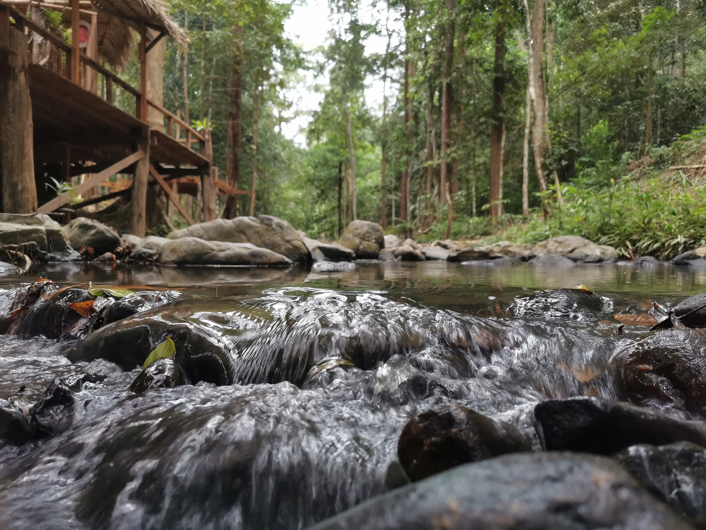


National Park · Songkhla
Khao Nam Khang National Park
อุทยานแห่งชาติเขาน้ำค้าง
Where Rainforest, Mountain Mist and Borderland History Meet
Songkhla · Southern Thailand · Thai–Malaysian Border
A ThailandLover guide to a dew-mountain forest where waterfalls, wildlife and a hand-dug underground tunnel share one landscape.
A Forest That Is Also an Archive
Hidden among the forested mountains of southern Songkhla, close to the Thai–Malaysian border, Khao Nam Khang National Park is a destination where nature and history are inseparable. This ThailandLover guide covers the legally protected park — rainforest, waterfalls and the historical tunnel — not the entire border landscape of Songkhla.
The park is characterised by long, complex mountain ranges, humid evergreen forest, waterfalls, streams and a cool highland environment. Beneath this seemingly peaceful landscape lies one of the most remarkable historical stories in Southern Thailand.
For decades the mountains were a remote borderland and an important base of armed communist movements on the Thai–Malaysian frontier. Deep inside the forest, underground tunnel systems were constructed as shelters, command centres, medical facilities and living quarters. Today the forest has reclaimed much of the landscape. The tunnels remain.
That is what makes Khao Nam Khang different. It is a national park where rainforest is also an archive of history — a standout in ThailandLover’s Nature & Parks collection.
At a Glance
- Official Name
- Khao Nam Khang National Park
- Thai Name
- อุทยานแห่งชาติเขาน้ำค้าง
- Province
- Songkhla, Southern Thailand
- National Park
- 65th national park of Thailand · first in Songkhla
- Gazetted
- 22 July 1991
- Area
- Approximately 132,500 rai / 212 km²
- Highest Peak
- Khao Nam Khang · approximately 648 metres
- Mountain System
- San Kala Khiri / Thai–Malaysian border mountains
- Districts
- Na Thawi and Sadao
- Main Ecosystem
- Moist evergreen forest
- Main Historical Site
- Khao Nam Khang Historical Tunnel · Ban Piyamit 5
- Major Waterfalls
- Ton Lat, Ton Dat Fa, Wang Luang Phrom, Phru Ching and Ton Mai Pak
The Mountain of Dew
เขาน้ำค้าง · The Meaning of the Name
The name Khao Nam Khang literally evokes a “dew mountain.” According to the traditional local account, people who climbed to the upper mountain encountered an unusual phenomenon: even during the daytime, droplets of dew could remain on the tips of grasses, forming fine, web-like patterns resembling spider webs. The mountain was also known for its cool climate.
High elevation, cool air, persistent moisture and mountain mist gave rise to the name. The story has become part of the cultural identity of the mountain.
A Cool Mountain in Southern Thailand
Khao Nam Khang is not a particularly high mountain by national standards — approximately 648 metres. Yet its environment can feel distinctly cooler and wetter than the surrounding lowlands. The mountain lies within a humid southern climate influenced by both the Northeast Monsoon and Southwest Monsoon.
Local descriptions identify a long rainy season, broadly from May through January, while the relatively warmer and drier period is generally February through April. Elevation and rainfall create the damp, green character of the forest: mist around ridges, water in streams, moss on shaded rocks, ferns and orchids beneath the canopy.
Geography and Watershed
The park consists of a complex series of mountain ridges extending toward the Thai–Malaysian border. High points include Khao Nam Khang, Khuan Saya, Khuan Khao Mai and other ridges of the border mountain system. The landscape is not one isolated summit. It is a continuous system of ridges, valleys and forested slopes.
That geography was historically significant. The rugged terrain was difficult to access and easy to defend. The same characteristics that made the landscape valuable for wildlife and watershed protection also made it suitable for guerrilla bases during periods of armed conflict.
The protected area extends through Na Thawi District — the western and central part, including headquarters and the historical tunnel — and Sadao District, extending toward the border. Forested mountains provide headwaters for Khlong Na Thawi, Khlong Prik, Khlong Thap Chang, Khlong Sai Khao and smaller mountain streams.
Rain falls on the mountain → forest absorbs and slows the water → streams form in the valleys → waterfalls appear where the terrain drops → rivers continue toward the lowlands.

Moist Evergreen Forest
Most of Khao Nam Khang is covered by moist evergreen forest — the type that gives the park its deep-green appearance. The canopy can be dense and multilayered, with tall trees rising above palms, vines, ferns and other shade-loving vegetation.
Reported trees include Hopea and related dipterocarps (malut), takian, yang, payom, krabak, champa, sia daeng, khai khiao, kha nang, taew, mang-kha, wild fig-related species and wild mango. The forest floor contains palms, rattan, bamboo, rakam, orchids, ferns, mosses and other moisture-loving plants.
Along shaded trails and streams, ferns, moss, orchids, rattan, bamboo and wild palms are indicators of the forest’s microclimate. Where moisture remains high, moss covers rocks. Where light is filtered, ferns occupy the understory. Where branches remain humid, orchids and epiphytes can establish themselves.
Khao Nam Khang is best experienced slowly. The smaller details reveal the forest.
Wildlife & Birdlife
Published surveys and park information have recorded wild boar, bear, muntjac, serow, long-tailed macaque, gibbon, Malayan tapir, black leopard / black panther, mouse deer, civets, turtles, monitor lizards and numerous birds. Some of these species are extremely difficult to encounter. A visitor should not expect to see a tapir, serow or large carnivore simply because the species is recorded. The forest is their habitat. Human visitors are temporary guests.
Recorded birds include hornbills, Great Argus, pheasants, Chestnut-necklaced Partridge, Gold-whiskered Barbet, Common Myna, Oriental Magpie-Robin and other forest birds. Enter the forest early and remain quiet. The forest can appear empty at first. Then the soundscape begins: a call from the canopy, wingbeats in the understory, a distant hornbill.
In Khao Nam Khang, listening is often as important as looking.
The Waterfalls of Khao Nam Khang
Because the mountain receives substantial rainfall, numerous streams descend through the forest. Where the terrain changes abruptly, waterfalls form. Among the better-known are Ton Lat, Ton Dat Fa, Wang Luang Phrom, Phru Ching, Ton Mai Pak and other smaller forest waterfalls. Some are gentle and moss-covered. Some fall over rock ledges. Others are deeper within the forest and require longer approaches.
- Ton Lat Waterfall
- น้ำตกโตนลาด. Rather than falling from one enormous vertical cliff, the water moves across a long sloping rock surface, creating a broad and continuous flow. The rock is covered with moss and moisture-loving vegetation. The stream continues into a natural pool and forest channel. Quieter. More intimate. More integrated with the forest: water + moss + rock + fern + rainforest.
- Wang Luang Phrom Waterfall
- A smaller waterfall associated with the Ton Lat stream system, divided into two streams by a large rock in the middle. Below the falls is a deeper natural pool. Historical park information notes that the pool contains fish and remains a relatively undisturbed part of the forest.
- Ton Dat Fa Waterfall
- น้ำตกโตนดาดฟ้า. The stream drops from a rock formation whose upper section resembles a natural roof. Published national-park information describes the waterfall as approximately 20 metres high. The surrounding forest is dense and humid. Gibbon calls and forest birds may be heard around it.
- Phru Ching & Ton Mai Pak
- น้ำตกพรุชิง and Ton Mai Pak belong to the wider mountain-water network rather than a single monumental viewpoint. Access conditions can vary according to weather and seasonal trail management.
The waterfalls should not be treated as separate attractions. They are connected.
The Most Important Story: History
Nature is only half the story here. For much of the 20th century, the mountains around Khao Nam Khang were a difficult and sensitive borderland: dense forest, steep ridges, limited roads, proximity to Malaysia. These conditions made the area suitable for armed groups operating outside government control.
The historical narrative commonly presented at Khao Nam Khang concerns the Malayan Communist Party (MCP) and its armed forces, particularly the 8th Regiment, which operated from bases in the Khao Nam Khang region. Thai sources historically referred to these forces using terms such as โจรจีนคอมมิวนิสต์มลายา. Modern historical accounts more precisely identify the movement as the Malayan Communist Party / Malayan Communist armed movement, whose bases extended into southern Thailand.
This distinction matters because Khao Nam Khang’s history is connected not only to Thai domestic politics, but also to the wider history of the Malayan Emergency and the armed communist movement in the Malay Peninsula.
From World War II to the Border Stronghold
The Malayan Communist movement initially developed in British Malaya and participated in resistance against the Japanese occupation. After the war, relations with colonial and later Malaysian authorities deteriorated. As security pressure increased, communist forces established bases in the dense forests along the Thailand–Malaysia frontier. Khao Nam Khang became one of these important borderland strongholds.
The remote mountain environment provided natural concealment, difficult terrain, forest resources, access to border routes and defensive advantages. Historical research identifies the 8th Regiment as operating in the Khao Nam Khang mountain area between Na Thawi and Sadao. This was not simply a temporary camp. The forest supported a functioning underground community: living areas, command and medical facilities, communications, food preparation, training, storage and political education. And beneath the mountain: the tunnel.
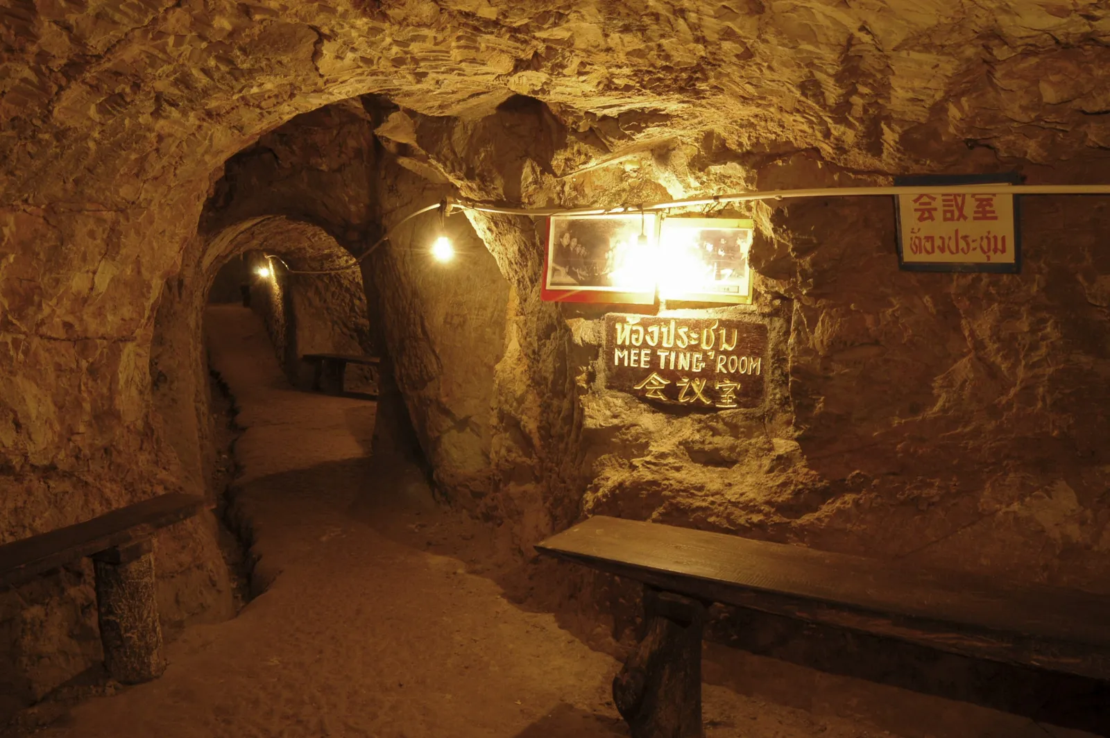
Khao Nam Khang Historical Tunnel
อุโมงค์ประวัติศาสตร์เขาน้ำค้าง
The historical tunnel is the most important historical attraction in the park. It sits around 4 kilometres from headquarters, in the Khao Nam Khang area of Khlong Kwang Subdistrict, Na Thawi District, Songkhla, and is associated with Ban Piyamit 5, a former communist settlement. Today visitors can enter parts of the underground complex and see how the mountain was transformed into a concealed base.
The tunnel was excavated manually. Historical accounts say construction began around 1972 (B.E. 2515) and took approximately two years, with a workforce commonly described as about 200 people per day. The resulting system extends for roughly one kilometre, with multiple passages and three levels, connected by stairways, and approximately 16 entrances and exits. If one entrance became dangerous, occupants could use another route.
Because the tunnel is an irregular hand-excavated complex rather than a modern engineered tunnel, published measurements can vary. For ThailandLover, the safest description is: a hand-dug underground complex extending for roughly one kilometre across three levels, with numerous entrances and interconnected passages.
It was not simply a hiding place. Historical descriptions identify meeting rooms, administrative rooms, a radio room, a medical room, kitchen, leaders’ quarters, storage, resting areas, toilets, training areas, weapons storage and political-education facilities. The medical section treated wounded and sick members. The tunnel had to support life as well as combat: food, water, medical care, communication, education, sleep, command and security.
Military base + shelter + hospital + command centre + political community — a hidden village under the mountain.
Ban Piyamit 5 and the End of Armed Conflict
The settlement formed part of the wider network of communities connected with the Malayan Communist movement in southern Thailand. After the conflict ended, former members and their families remained connected to these communities. Today the site is presented primarily as a historical and educational attraction.
Thai historical accounts associate the decisive government operation in the Khao Nam Khang area with Operation Tai Rom Yen — ยุทธการใต้ร่มเย็น. The strategy combined military action with political measures under the principle commonly described as “politics leading the military.” The Thai 4th Army Region and the combined civilian–police–military force 43 (พตท.43) participated. According to the historical account, government forces seized the communist operational base on 25 July 1980 (B.E. 2523).
The loss of the base did not immediately mean the wider movement had disappeared. By 1987, communist members in the Khao Nam Khang area were entering the process of becoming “participants in national development” — ผู้ร่วมพัฒนาชาติไทย. The wider Malayan Communist Party subsequently reached the Hat Yai Peace Agreement on 2 December 1989, formally ending its armed struggle.
Armed conflict → military pressure → political strategy → surrender and reintegration → historical preservation.
From Battlefield to National Park
Following the decline of armed conflict, the government began establishing the forest as a national park. Historical records show that the National Park Committee instructed the Forestry Department in 1983 to investigate the former stronghold and surrounding forest. A formal survey found approximately 220 km² of forest with rich natural resources, waterfalls and historical sites.
The relevant Royal Decree covered Pa Khao Daen, Pa Khao Nam Khang, Pa Khuan Si Reng, Pa Khuan Thang Saya, Pa Khuan Khao Mai and associated forest areas in parts of Na Thawi and Sadao. It was published in the Royal Gazette on 22 July 1991 (B.E. 2534). Khao Nam Khang became Thailand’s 65th national park — and the first in Songkhla Province.
The park has two forms of heritage. Natural: mountain forest, watersheds, waterfalls, wildlife, biodiversity, border ecosystems. Historical: former communist bases, the tunnel, Piyamit 5, evidence of armed conflict, underground infrastructure, and memories of political conflict and reconciliation. Few national parks in Thailand combine these two dimensions so directly.
A National Park on the Frontier
The mountains form part of the broader San Kala Khiri / Sankalakhiri mountain system along the border. The forest does not recognise political boundaries in the way humans do. Birds move. Wildlife moves. Water moves. Plants spread. The historical tunnel, however, exists precisely because humans created boundaries, conflicts and political territories.
Nature connects the two sides. History divided them.
From the upper ridges, the landscape extends toward the Thai–Malaysian frontier. The mountains, forest, weather and ecosystems are continuous. The political border is comparatively invisible from the natural landscape.
Underlying geology includes both limestone and granite, helping create rocky ridges, waterfall channels, natural pools, caves and mountain streams. Khao Nam Khang’s strength comes from rainfall, humidity, mountain terrain, evergreen forest and borderland connectivity — not from altitude alone.
How to Experience Khao Nam Khang
Visitors often associate Southern Thailand with beaches, islands, coral reefs and tropical resorts. Khao Nam Khang offers another Southern Thailand: mist, mountain forest, waterfalls, quiet roads, border villages, old tunnels and history.
- Begin at the park
- The forest immediately establishes the character of the destination.
- Follow the mountain road
- The landscape gradually becomes more remote.
- Visit a waterfall
- Listen to the water and observe the forest around it.
- Continue toward the historical zone
- The landscape begins to reveal another identity.
- Enter the tunnel
- The light disappears. The forest becomes an underground passage.
- Walk through the former base
- Rooms, stairways and exits reveal how people once lived beneath the mountain.
- Return to the forest
- The transition from darkness back into green rainforest becomes part of the experience.
Perhaps the most striking moment is not standing beside a waterfall. It is the moment you leave the sunlight and enter the tunnel. Outside: trees, birds, rain, mountains, open sky. Inside: darkness, narrow passages, stairs, rooms, silence.
Today the tunnel no longer functions as a military facility. It has become a place for historical interpretation. A place once designed to hide people from armed conflict is now used to teach later generations about the consequences of conflict. Historical accounts note that restoration work was undertaken by former members of the movement, and the site was opened to the public in the 1990s.
How to Get There
Headquarters: Moo 1, Khlong Kwang Subdistrict, Na Thawi District, Songkhla 90160. The park can be approached from both the Na Thawi and Sadao / Hat Yai sides.
- From Songkhla city
- Published park information gives approximately 86 kilometres via Na Thawi (Songkhla–Na Thawi road to Pa Ching Intersection, then toward Na Thawi and the headquarters).
- From Hat Yai / Sadao
- Approximately 84 kilometres via Sadao, although actual travel time depends on road and traffic conditions.
- Historical tunnel
- About 4 kilometres from park headquarters, in the Ban Piyamit 5 area.
Responsible Travel
Khao Nam Khang deserves particularly careful tourism because of its dual heritage.
- Stay on designated trails
- Follow park instructions
- Do not remove plants, rocks or historical objects
- Do not damage tunnel structures or write on tunnel walls
- Do not disturb wildlife or enter restricted forest areas
- Carry rubbish out
- Avoid loud music
- Follow safety instructions around waterfalls
- Treat the tunnel as a place of learning rather than simply a photo opportunity
The forest is protected because it is alive. The tunnel is protected because it remembers.
Must-Experience
- 01 — Khao Nam Khang Mountain
- The cool, misty highland landscape that gave the mountain its name.
- 02 — Historical Tunnel
- Walk through the three-level underground complex that once served as a major communist base.
- 03 — Ban Piyamit 5
- Understand the former settlement associated with the tunnel.
- 04 — Ton Lat Waterfall
- Water flowing over a long moss-covered rock slope.
- 05 — Ton Dat Fa Waterfall
- The approximately 20-metre fall surrounded by dense rainforest.
- 06 — Wang Luang Phrom & Phru Ching
- Quieter forest waterfalls and the mountain-water system.
- 07 — Forest Trails
- Look for orchids, ferns, mosses and birds rather than simply searching for large animals.
- 08 — Borderland Landscape
- Understand how the mountains connect Thailand and Malaysia ecologically while separating them politically.
Essential Khao Nam Khang
- Name
- Khao Nam Khang National Park
- Thai
- อุทยานแห่งชาติเขาน้ำค้าง
- Province
- Songkhla
- Area
- Approximately 132,500 rai / 212 km²
- Established
- 22 July 1991 · 65th national park
- Highest Peak
- Khao Nam Khang · approximately 648 metres
- Districts
- Na Thawi and Sadao
- Main Forest
- Moist evergreen forest
- Main Waterfalls
- Ton Lat, Ton Dat Fa, Wang Luang Phrom, Phru Ching and Ton Mai Pak
- Historical Site
- Khao Nam Khang Historical Tunnel · Ban Piyamit 5
- Tunnel
- Three levels · about 16 entrances · roughly 1 km · built by hand from about 1972
- Headquarters
- Khlong Kwang, Na Thawi, Songkhla 90160
Frequently Asked Questions
- What is Khao Nam Khang National Park?
- Thailand’s 65th national park and the first in Songkhla, gazetted on 22 July 1991. About 132,500 rai / 212 km² of moist evergreen forest in Na Thawi and Sadao, with waterfalls and the historical tunnel.
- What does Khao Nam Khang mean?
- เขาน้ำค้าง literally evokes a “dew mountain.” Traditional accounts say that even in daytime, dew could remain on grass tips in fine, web-like patterns.
- What is the historical tunnel?
- A hand-dug underground complex of roughly one kilometre across three levels, with about 16 entrances. Construction began around 1972. Associated with Ban Piyamit 5 and the Malayan Communist Party’s 8th Regiment. Thai historical sources often used the term โจรจีนคอมมิวนิสต์มลายา.
- Is Ban Piyamit 5 the same as the national park?
- No. Ban Piyamit 5 is a historical settlement associated with the tunnel. The park covers about 212 km² across parts of Na Thawi and Sadao.
- How do I get there?
- Headquarters are at Moo 1, Khlong Kwang, Na Thawi, Songkhla 90160. About 86 kilometres from Songkhla city via Na Thawi and about 84 kilometres from Hat Yai via Sadao. The tunnel is about 4 kilometres from headquarters.
- When is the best time to visit?
- A long rainy season, broadly May–January, and a relatively warmer, drier period generally February–April. Check current access with the park.
- How do I contact the park?
- DNP lists 0 7480 5342 and Khaonamkang@gmail.com. Headquarters: Moo 1, Khlong Kwang, Na Thawi, Songkhla 90160.
Related Destinations
- San Kala Khiri National Park
- The same border mountain system — another face of the Thai–Malaysian highland forest.
- Thale Ban National Park
- Border wetlands and forest in Satun, another landscape where Thailand meets Malaysia.
- Khao Luang National Park
- Southern Thailand’s highest peak — a mountain-rainforest counterpart further north.
- Nature & Parks
- More protected landscapes across ThailandLover’s national-park collection.
Location
Find Khao Nam Khang National Park
Moo 1, Khlong Kwang Subdistrict, Na Thawi District, Songkhla 90160