

Nature & Parks · Chiang Mai
Op Luang National Park
อุทยานแห่งชาติออบหลวง
Where the River Cuts a Passage Through the Mountains
Chom Thong · Hot · Mae Chaem · Chiang Mai · Northern Thailand
A mountain river disappears between towering walls of rock — a dramatic gorge, waterfalls, caves, hot springs and prehistoric rock art in southern Chiang Mai.
A River Through Stone
In the mountains of southern Chiang Mai, a river disappears between towering walls of rock.
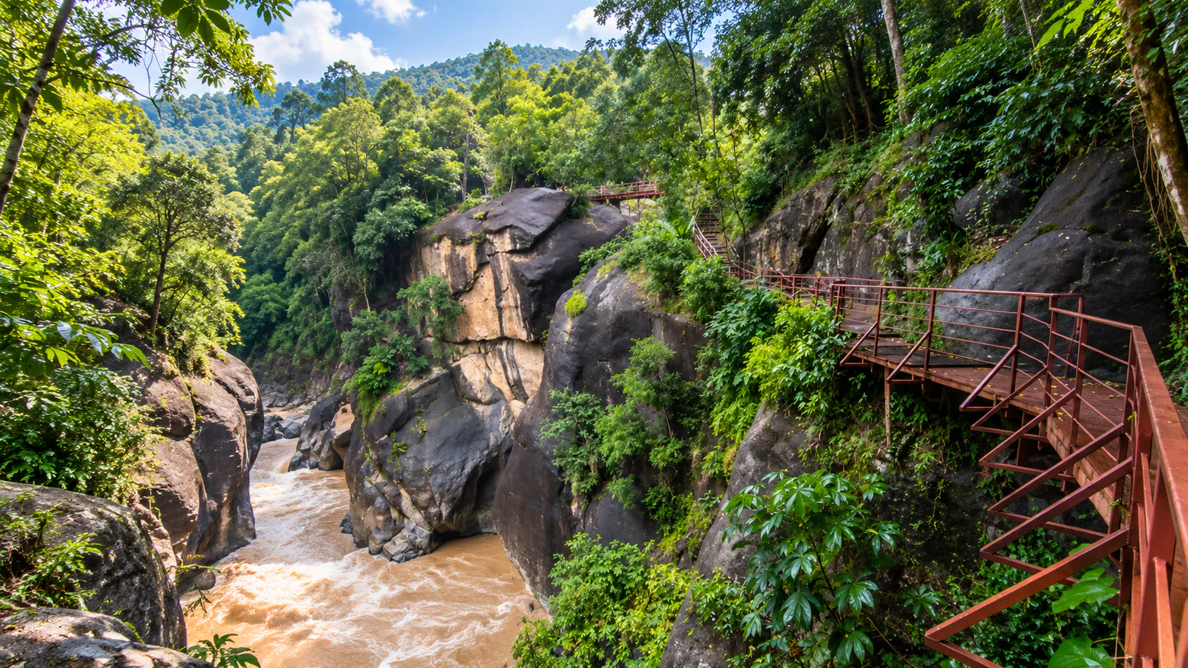
The landscape suddenly narrows. The forest closes in. And the Mae Chaem River forces its way through a dramatic gorge carved into the mountains.
This is Op Luang.
Located across Chom Thong, Hot and Mae Chaem districts in Chiang Mai Province, Op Luang National Park is a mountainous protected landscape defined by rivers, cliffs, waterfalls, caves, forests, hot springs — and one of northern Thailand’s most remarkable natural gorges.
At the centre of the park, the Mae Chaem has carved a narrow passage through the rock. Beyond it lies a much larger mountain ecosystem: waterfalls such as Mae Bua Kham, Mae Chon and Mae Tia; caves including Tham Tong and Tham Tu Pu; the Thep Thanom hot spring; extensive forests; and an archaeological landscape with prehistoric rock art and artefacts.
Not simply a viewpoint — a destination where geology, water, forest, archaeology and human history meet.
At a Glance
- ~553 km²
- About 345,625 rai across Chom Thong, Hot and Mae Chaem.
- ~300 m
- Length of Op Luang Gorge — the park’s signature landscape.
- 68th
- Thailand’s national park number — established 4 December 1991.
- ~100 km
- South of Chiang Mai city along Highway 108, depending on route.
- Official English name
- Op Luang National Park
- Thai name
- อุทยานแห่งชาติออบหลวง
- Region
- Northern Thailand
- Province
- Chiang Mai
- Districts
- Chom Thong, Hot and Mae Chaem
- Main river
- Mae Chaem River
- Signature attraction
- Op Luang Gorge
- Landscape
- Mountains, river gorge, cliffs, waterfalls, caves, hot springs and forests
- Area
- Approximately 345,625 rai / 553 km²
- Established
- 4 December 1991
- National park number
- Thailand’s 68th National Park
- Mountain range
- Thanon Thong Chai Range
- Major archaeological area
- Doi Pha Chang and prehistoric rock-art sites
- Major waterfalls
- Mae Bua Kham, Mae Chon, Mae Tia
- Major cave sites
- Tham Tong, Tham Tu Pu
- Hot spring
- Thep Thanom
- Management
- Department of National Parks, Wildlife and Plant Conservation
Where Is Op Luang?
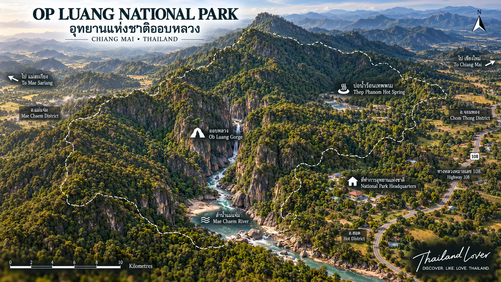
Op Luang National Park lies in Chiang Mai Province in northern Thailand, approximately 100–105 kilometres south of Chiang Mai city depending on the route and starting point.
The park extends across:
- Chom Thong District
- Hot District
- Mae Chaem District
The protected landscape forms part of the Thanon Thong Chai mountain range — the same broader highland system that includes the landscape around Doi Inthanon.
To the north lie high mountains associated with Doi Inthanon. To the west and southwest are the valleys around Mae Chaem. To the east and southeast the land descends toward Hot and the Ping River system.
Op Luang occupies a transition zone between high mountain forests and the lower valleys of northern Thailand.
The Meaning of Op Luang
The name comes from northern Thai landscape language.
- Op / ออบ
- A narrow gorge or passage — a corridor of rock and water.
- Luang / หลวง
- Large or great — the scale of the passage.
Together: the Great Gorge — a remarkably literal geographical name.
Mountain Landscape & Thanon Thong Chai
Op Luang is dominated by complex mountain terrain — long ridges, deep valleys and river channels cutting between them.
- Steep mountain slopes and rocky ridges
- Deep valleys and river gorges
- Forest-covered hills
- Waterfalls, caves and hot springs
Belonging to the Thanon Thong Chai mountain system links Op Luang to some of northern Thailand’s most important highland forests. The gorge is not an isolated canyon — it is part of a much larger mountain ecosystem.
The Mae Chaem River
The river at the heart of Op Luang
The Mae Chaem River is the defining watercourse of the park. It flows through the mountains and eventually joins the larger river systems of northern Thailand.
At Op Luang, the river encounters geological formations that narrow its channel. Over long periods, flowing water has eroded and shaped the surrounding rock — creating one of the park’s most visually distinctive landscapes: a river passing through a narrow mountain gorge.
The river also explains why Op Luang has mattered beyond tourism. It is part of a broader watershed that supports forests, agriculture and communities downstream.
The river is not simply scenery — it is the geological force that carved the park’s identity.
Op Luang Gorge
The signature landscape
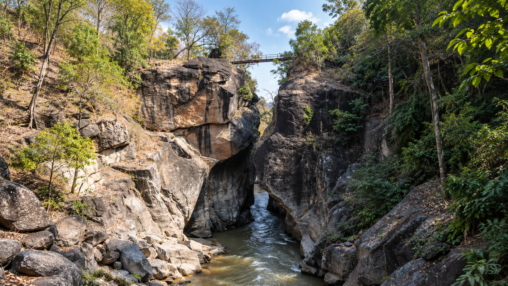
Here the Mae Chaem passes between steep rock walls. The gorge is approximately 300 metres long. Its narrowest sections create a strong sense of enclosure — the river appears small against the cliffs, forest rises above the stone, and the sound of water echoes through the corridor.
How the gorge was formed
Op Luang is fundamentally a story of rock and water. Geological forces uplifted the mountains; fractures developed within the rock; the Mae Chaem exploited those weaknesses. Water, sediment and time gradually widened and deepened the passage — not a single sudden event, but a long process still continuing with every flood and rainy season.
The rock walls & the bridge
The cliffs are not simply vertical walls. Their surfaces hold grooves, ridges, fractures, rounded forms and water-shaped textures — especially visible in morning and late-afternoon light.
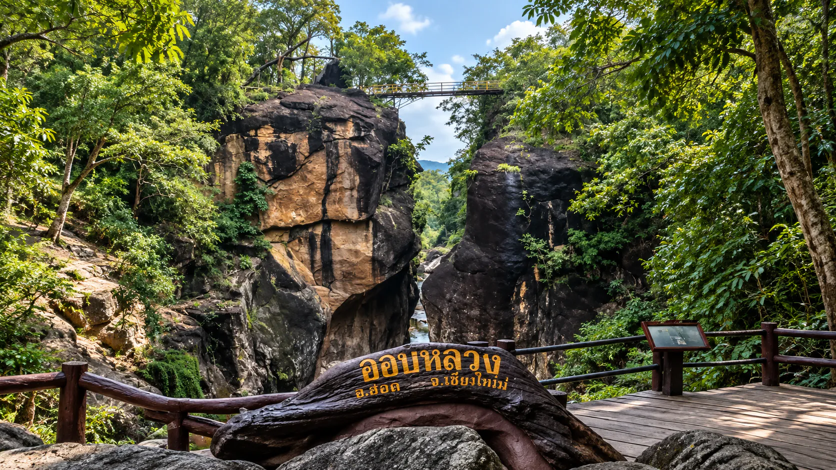
A bridge crosses the gorge and provides one of the most recognisable viewpoints. From above, visitors see the river compressed between the rocks — the scale relationship of water → rock → forest — with a safer vantage for those who prefer not to walk close to the river.
Seasonal river
Water level changes with season and rainfall. Wet periods strengthen the current; drier periods expose rock and shallower sections. The same viewpoint can look completely different at different times of year.
Waterfalls
Mae Bua Kham
A forest waterfall commonly described as approximately 50 metres high. Vertical water moving through forest — a different character from the enclosed gorge.
Mae Chon
Notable for its width — commonly about 80 metres. A broad sheet or series of streams across the rock face; after heavy rain it becomes substantially more powerful.
Mae Tia
Among the larger falls associated with the park — commonly about 80 metres high. More remote, better for travellers seeking a deeper nature experience than a short sightseeing stop.
Gorge for enclosure. Waterfalls for vertical drama. Choose according to access and weather.
Thep Thanom Hot Spring
Where heat meets the mountain forest
On the western side of the park, Thep Thanom provides a striking contrast with cool mountain streams and waterfalls. The same geological forces that created mountains and fractures can allow groundwater to circulate deep underground, become heated and return to the surface.
Within one protected landscape: cold river water, waterfalls, underground caves, hot geothermal water and mountain rock — connected by the geology beneath the forest.
Caves
Tham Tong
Described as extending through a combination of granite and limestone environments, with tunnels leading into the mountain and different chambers underground.
Tham Tu Pu
Known for stalactites, stalagmites, underground chambers and limestone formations that develop extremely slowly — a single touch can damage surfaces that took centuries or millennia to form.
Prehistoric Op Luang
Where nature meets human history
One of the most remarkable aspects of Op Luang is its archaeological significance. Rock paintings, stone tools, ornaments and other materials have been discovered in the landscape — making it unusual among Thailand’s nature destinations.
Doi Pha Chang
The Doi Pha Chang area contains a significant prehistoric rock painting depicting an elephant — one of the most recognisable archaeological features associated with the park. People were observing, representing and interacting with animals and landscape here long before modern Chiang Mai boundaries existed.
Rock art near the gorge
Additional prehistoric rock-art sites have been reported near the main gorge. Findings in the wider area have included rock paintings, stone tools, ornaments and other archaeological materials — evidence of long-term human occupation in the mountain landscape.
- Geological time
- Rocks shaped by water and geological processes over immense periods.
- Human time
- People living, travelling and leaving traces for thousands of years.
The park has traditionally offered an archaeological interpretation route connecting rock-art sites, geological formations, river landscapes and forest — especially suitable for educational travel.
Forest Ecosystems
Main vegetation communities include mixed deciduous forest, deciduous dipterocarp forest, evergreen forest, bamboo-dominated areas and riverine vegetation — transitions shaped by elevation, rainfall, soil, slope, aspect and water availability.
- Mixed deciduous
- Lower and intermediate elevations — green in the wet season; golden and open in the dry season.
- Dipterocarp
- Dryer slopes — Dipterocarpus, Shorea, Xylia, Afzelia, Lagerstroemia, Terminalia; more open canopies.
- Evergreen
- Wetter valleys and moist mountain environments — denser shade year-round.
- Bamboo & flora
- Dense stands as wildlife habitat; Hopea, teak, palms, ferns and related northern forest plants.
Wildlife
Life beyond the gorge
Published park information associates the forest with mainland serow, sambar deer, muntjac, wild boar, Asiatic black bear, Sunda pangolin, civets, Phayre’s leaf monkey, northern treeshrew, Siamese hare, squirrels, forest birds, reptiles and amphibians.
ThailandLover describes these as species associated with the ecosystem — not animals visitors are guaranteed to see. Most larger mammals are elusive and more active away from heavily visited areas.
Mainland serow & bear
Serows favour rugged mountain slopes. Asiatic black bears are large and potentially dangerous — never approach or feed. Remain calm, keep distance and follow ranger instructions.
Birds & river life
Forest passerines, bulbuls, drongos, pigeons, woodpeckers and raptors — early morning is best. The Mae Chaem and tributaries support fish, aquatic insects, crustaceans and riparian plants. Never handle wildlife; some snakes can be venomous.
Climate & Best Time
- Cool season
- November–February — most comfortable for hiking; higher elevations can be cold at night.
- Hot season
- March–May — hot and dry at lower elevations; forest fire and haze can matter.
- Rainy season
- June–October — greener forest, stronger waterfalls; trails and rocks can be slippery.
- Archaeology & views
- Cooler, drier months often suit outdoor trails and clearer mountain visibility.
Dry vs rainy landscapes
In the dry season, deciduous forests open and golden tones appear — the gorge can feel brighter. In the rainy season, Op Luang becomes intensely green, mist develops, rock darkens and water volume rises — with increased risk of flash floods, strong currents, landslides and temporary trail closures.
Northern Thailand haze
Late winter and early hot season can bring burning and haze that reduce visibility, outdoor comfort and photography quality. Check current air-quality conditions before travelling.
Things to Do
- 1. Cross the gorge
- Stand above the Mae Chaem and look down into the narrow canyon.
- 2. River & rock
- Observe how water interacts with stone along the main nature route.
- 3. Archaeology
- Explore prehistoric rock-art sites where officially accessible.
- 4. Waterfalls
- Mae Bua Kham, Mae Chon or Mae Tia — according to access and season.
- 5. Hot spring & caves
- Thep Thanom; Tham Tong and Tham Tu Pu where current access permits.
- 6. Birds & photos
- Early morning birdwatching; photograph river + cliffs + forest together.
Hiking levels
- Easy — main gorge and visitor area
- Moderate — waterfall and nature trails
- More demanding — remote waterfall routes, cave areas, longer forest trails
- Specialist — extended mountain trekking with local guidance
Not every attraction can be reached by road. The main gorge nature trail is relatively short — genuine landscape without a full-day trek.
Photography & Birdwatching
The classic Op Luang shot
River below + cliffs on both sides + forest above. The bridge is a natural elevated viewpoint. Look for rock detail, water erosion textures and calmer river reflections.
Waterfalls
Faster shutter to freeze drops; slower shutter for smooth movement where conditions are safe.
Birdwatching
Arrive early. Walk slowly. Listen first, look second. Binoculars often beat a long lens.
Cave visits
Good-grip footwear, headlamp, water, appropriate clothing and a guide where required. Never enter in dangerous weather.
River, Wildlife & Responsible Tourism
River safety
- Never swim during heavy rain or stand in strong current
- Do not cross during high water or climb wet cliffs
- Never jump from rocks or approach falls from unsafe edges
- If water turns muddy or rises quickly, move away — upstream rain can raise levels even when it is dry where you stand
Wildlife & heritage
- Never feed or approach large mammals
- Do not scratch rock or carve the gorge
- No soap or chemicals in the river
- Protect archaeology, caves, wildlife and forest — take all rubbish out
Getting There
A common route from Chiang Mai:
Chiang Mai → Highway 108 → Chom Thong → Hot → Op Luang
The park lies approximately 100–105 kilometres south of Chiang Mai city. Highway 108 is the main road connecting the city with southern Chiang Mai Province. From Chom Thong continue south toward Hot; the entrance is accessible from the highway. Visitors travelling between Mae Chaem and Hot can fold Op Luang into a wider mountain itinerary.
Driving
The Highway 108 approach is straightforward. Internal roads toward individual attractions can be more rural. In the rainy season expect wet roads, mud, slippery surfaces and possible temporary closures.
Transport
Easiest by private car, rental, taxi or organised tour. Public transport runs along Highway 108, but reaching sites inside the park is difficult without private transport.
Camping, Accommodation & Fees
Camping is available under current management arrangements — confirm campsite availability, seasonal opening, tent rental, fees and fire restrictions before travelling.
Basic park accommodation may be available. ThailandLover links visitors to the current DNP reservation system rather than hard-coding room rates.
The published DNP fee schedule places Op Luang in Group 1: Thai entrance fees of 20 baht for children and 40 baht for adults; foreign visitor fees of 100 baht for children and 200 baht for adults in the referenced regulation. Treat fees as current-reference information — regulations can change.
Main visitor area facilities may include park office, parking, toilets, rest areas, camping, accommodation, nature trails and interpretation. Remote waterfalls and caves are more limited.
Suggested Experiences
- Half day
- Early drive south on 108 → gorge & bridge → main nature route → lunch → archaeology or one nearby attraction → continue to Hot or Mae Chaem.
- Full day
- Morning gorge → prehistoric trail → afternoon waterfall, cave or hot spring by access and weather → return or overnight toward Mae Chaem.
- Two days
- Day 1: gorge, archaeology, Mae Bua Kham. Day 2: Mae Chaem mountains, waterfall or cave, return via 108.
- What to bring
- Water, comfortable shoes, hat, sunscreen, insect repellent, rain jacket, first-aid kit, camera, binoculars. Caves: headlamp, grip shoes, dry bag.
Why Op Luang Is Different
- Geology
- A river gorge carved through mountain rock.
- Water
- Mae Chaem, waterfalls, streams, hot spring and caves.
- Forest & wildlife
- Multiple northern forest ecosystems and mountain species.
- Archaeology
- Prehistoric rock art and a landscape used for thousands of years.
Water shaped the gorge. The forest protects the mountains. The mountains feed the river. People have travelled through this landscape for thousands of years.
Op Luang, Doi Inthanon & Mae Chaem
With Doi Inthanon
Connected through the Thanon Thong Chai system, but different experiences. Doi Inthanon: high summit, cloud forest, Thailand’s highest point. Op Luang: river gorge, archaeology, caves, hot spring. Visiting both completes a southern Chiang Mai mountain picture.
With Mae Chaem
Closely linked to the Mae Chaem cultural landscape — mountain valleys, agricultural communities and distinctive local culture. Op Luang works best as part of a broader mountain route, not only a standalone stop.
Before You Go
Never touch archaeological paintings, remove artefacts, break cave formations, feed wildlife, swim in dangerous conditions, climb unstable cliffs, leave rubbish, light fires outside designated areas, or enter closed caves or trails.
Confirm opening status, trail and cave access, river conditions, weather, haze, camping and current fees with park authorities or the Department of National Parks before travelling.
Frequently Asked Questions
- What is Op Luang National Park?
- A protected mountain landscape in Chiang Mai centred on Op Luang Gorge, where the Mae Chaem River flows between steep rock cliffs — with waterfalls, caves, a hot spring and prehistoric sites.
- Where is it?
- Chiang Mai Province across Chom Thong, Hot and Mae Chaem districts, roughly 100–105 km south of Chiang Mai city.
- What is Op Luang Gorge?
- The signature landscape — a narrow Mae Chaem River passage between towering cliffs, about 300 metres long.
- What river flows through the gorge?
- The Mae Chaem River.
- What waterfalls are there?
- Mae Bua Kham (~50 m high), Mae Chon (~80 m wide) and Mae Tia (~80 m high) — commonly published reference figures.
- Are there caves?
- Yes — including Tham Tong and Tham Tu Pu. Follow current access and safety rules.
- Are there prehistoric sites?
- Yes — rock art, tools and ornaments; Doi Pha Chang is known for an elephant rock painting.
- Can I visit as a day trip from Chiang Mai?
- Yes — the main gorge is road-accessible and works as a full-day nature and cultural excursion.
- Best time to visit?
- November–February for comfort; rainy season for green forest and stronger falls; check haze in late winter / early hot season.
- Is it Thailand’s 68th national park?
- Yes — officially established 4 December 1991.
Where the River Meets Human Memory
ThailandLover editorial story
The road leaves Chiang Mai behind. Buildings become fewer. The mountains begin to rise. Then you hear the river.
At Op Luang, the Mae Chaem enters a narrow passage. The mountains close around it. Stone rises on both sides. The river continues — it does not stop for the cliffs. It has been here longer than the road, longer than the park, longer than the villages around it.
Water found a weakness in the mountain and kept moving. Year after year. Rain after rain. Flood after flood. Eventually, a gorge appeared.
People came too. They left paintings on rock. They left tools. They left traces of their lives. And now, thousands of years later, travellers stand in the same landscape.
The river is still moving. The mountain is still standing. The forest is still growing. And Op Luang continues its story.
SEE · FEEL · DISCOVER
- SEE
- The Mae Chaem disappearing between towering cliffs. Waterfalls in northern forest. Prehistoric images on ancient rock. Mist moving through the mountains.
- FEEL
- Cool mountain air. The sound of water inside the gorge. Stone beneath your feet. The quiet of a forest far from the city.
- DISCOVER
- A landscape where geology and archaeology meet. A river that carved a passage through the mountains. A side of Chiang Mai that existed long before modern tourism.
More Chiang Mai Nature
- Ob Khan National Park
- Mae Khan River gorge closer to Chiang Mai — a separate park from Op Luang.
- Doi Inthanon National Park
- Thailand’s highest summit and high-altitude mountain ecosystems.
- Mae Wang National Park
- Mountain forest and waterfall landscapes on southern Chiang Mai nature routes.
- All Nature & Parks
- Browse ThailandLover’s national park guides across the country.
Location
Find Op Luang
Chom Thong, Hot & Mae Chaem Districts, Chiang Mai Province, Thailand